
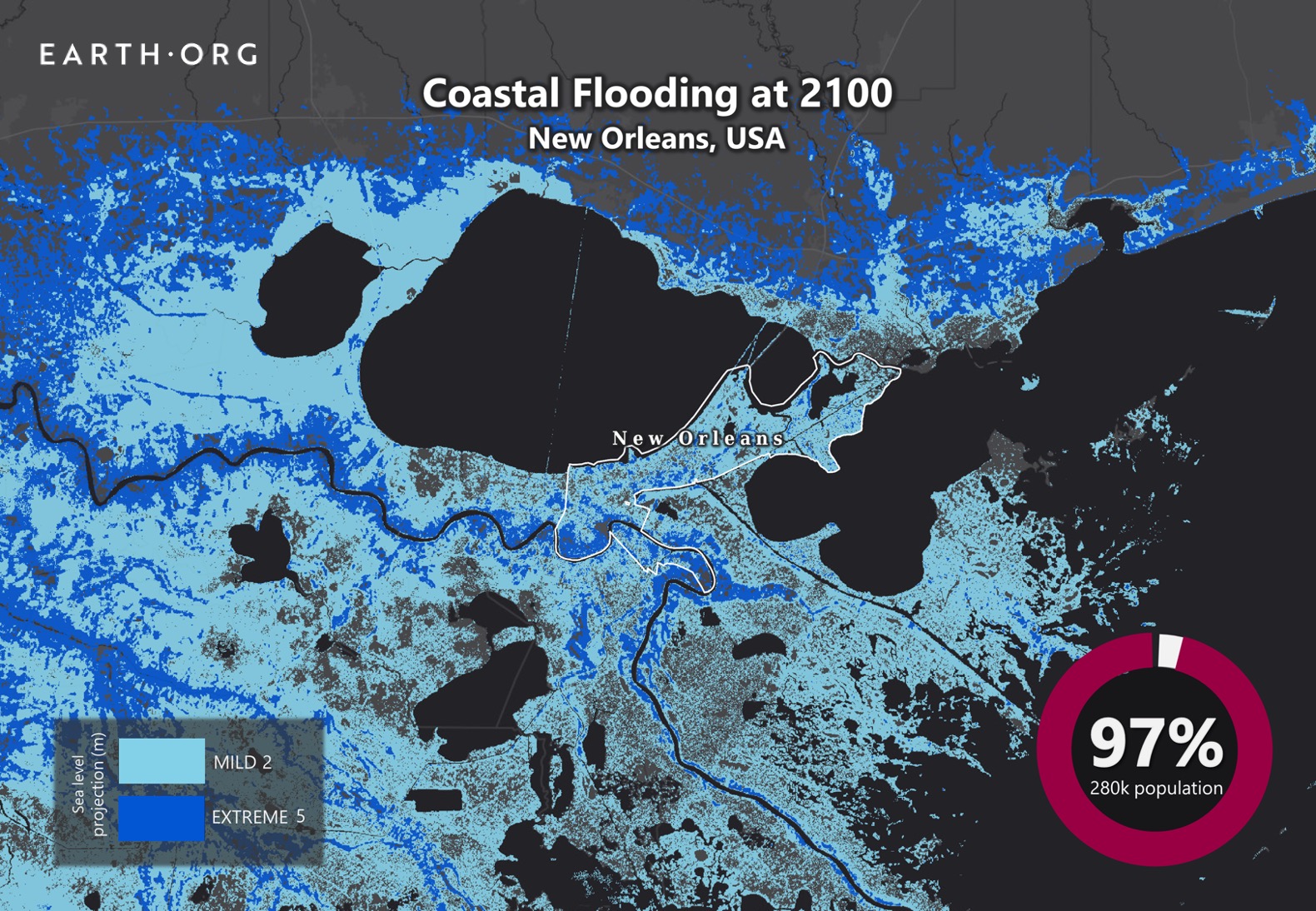
By 2100, sea‑level rise could add between 0.5 and 1.2 meters to New Orleans’ shoreline, reshaping flood risk, infrastructure, and community resilience, though exact outcomes depend on emissions pathways and local adaptation.
Quick Answer
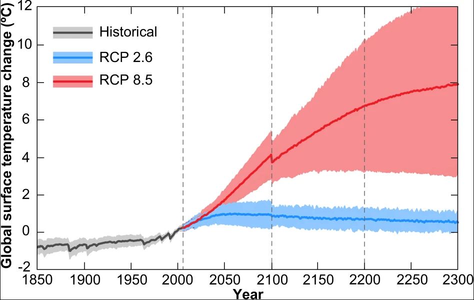
Scientific assessments indicate that, under a high‑emissions scenario (Representative Concentration Pathway 8.5), global mean sea level could rise 0.84 to 1.00 meters by 2100, with the Gulf of Mexico experiencing slightly higher values because of regional subsidence and ocean dynamics. For New Orleans, this translates to an increase of roughly 0.5 to 1.2 meters relative to present‑day levels. The primary consequence is a dramatic rise in the frequency of coastal flooding, even without a storm, and a heightened vulnerability of levee systems, low‑lying neighborhoods, and critical infrastructure. However, uncertainties in ice‑sheet dynamics and future greenhouse‑gas emissions mean the exact magnitude remains a range rather than a single figure.
Key Takeaways
- Sea‑level rise by 2100 is projected at 0.5–1.2 meters for New Orleans, depending on emission pathways and local land subsidence.
- Higher water levels increase the baseline for storm surge, making even moderate storms capable of causing extensive flooding.
- Levee performance, wetland loss, and socioeconomic inequities amplify exposure and vulnerability.
- Robust evidence supports the direction of change; uncertainties remain in ice‑sheet contributions and exact local subsidence rates.
- Adaptation options—elevated structures, restored wetlands, and adaptive levee design—can reduce risk but require substantial investment and equitable implementation.
What Is Sea‑Level Rise in New Orleans by 2100?
Sea‑level rise (SLR) refers to the long‑term increase in the average height of the ocean relative to land. In the context of New Orleans, the phrase “What will sea levels look like by 2100?” asks for the projected change in water height at the city’s coastline by the end of the 21st century. The projection combines global ocean warming, melting of land‑based ice, and local land‑surface processes such as subsidence (the gradual sinking of the ground). The metric is usually expressed in meters (or feet) above a defined datum, often the North American Vertical Datum of 1988 (NAVD88). Understanding this change is essential because New Orleans lies largely below sea level and depends on levees, pumps, and wetlands for protection.
How Does Sea‑Level Rise Occur?
1. Thermal Expansion of Ocean Water
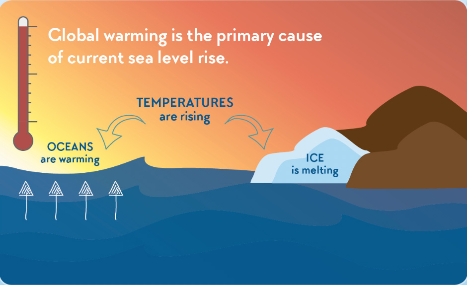
As the atmosphere warms, the upper layers of the ocean absorb heat and expand. This “thermal expansion” accounts for roughly one‑third of observed global sea‑level rise since the 1990s, according to the Intergovernmental Panel on Climate Change (IPCC) Fifth Assessment Report (2013).
2. Melting of Glaciers and Ice Sheets
Glaciers worldwide have been losing mass at an accelerated rate. More critically, the Greenland and Antarctic ice sheets contribute the majority of projected future sea‑level rise. The IPCC Sixth Assessment Report (2021) notes that uncertainties in ice‑sheet dynamics dominate the upper end of SLR projections.
3. Local Land Subsidence
New Orleans sits on deltaic sediments that are naturally compacting and on top of a former river channel that continues to sink. A US Geological Survey (USGS) study (2020) measured average subsidence rates of 0.5–1 cm yr⁻¹ in the city’s core, effectively adding to relative sea‑level rise.
4. Ocean Dynamics and Gravitational Effects
Changes in ocean circulation, such as a weakening of the Atlantic Meridional Overturning Circulation, can cause regional sea‑level variations. Additionally, the redistribution of water mass after ice melt alters Earth’s gravity field, causing higher sea level near the melting ice and lower levels far away—a process called “sea‑level fingerprinting.”
What Does the Evidence Show?
Multiple lines of evidence converge on a consistent picture of rising seas:
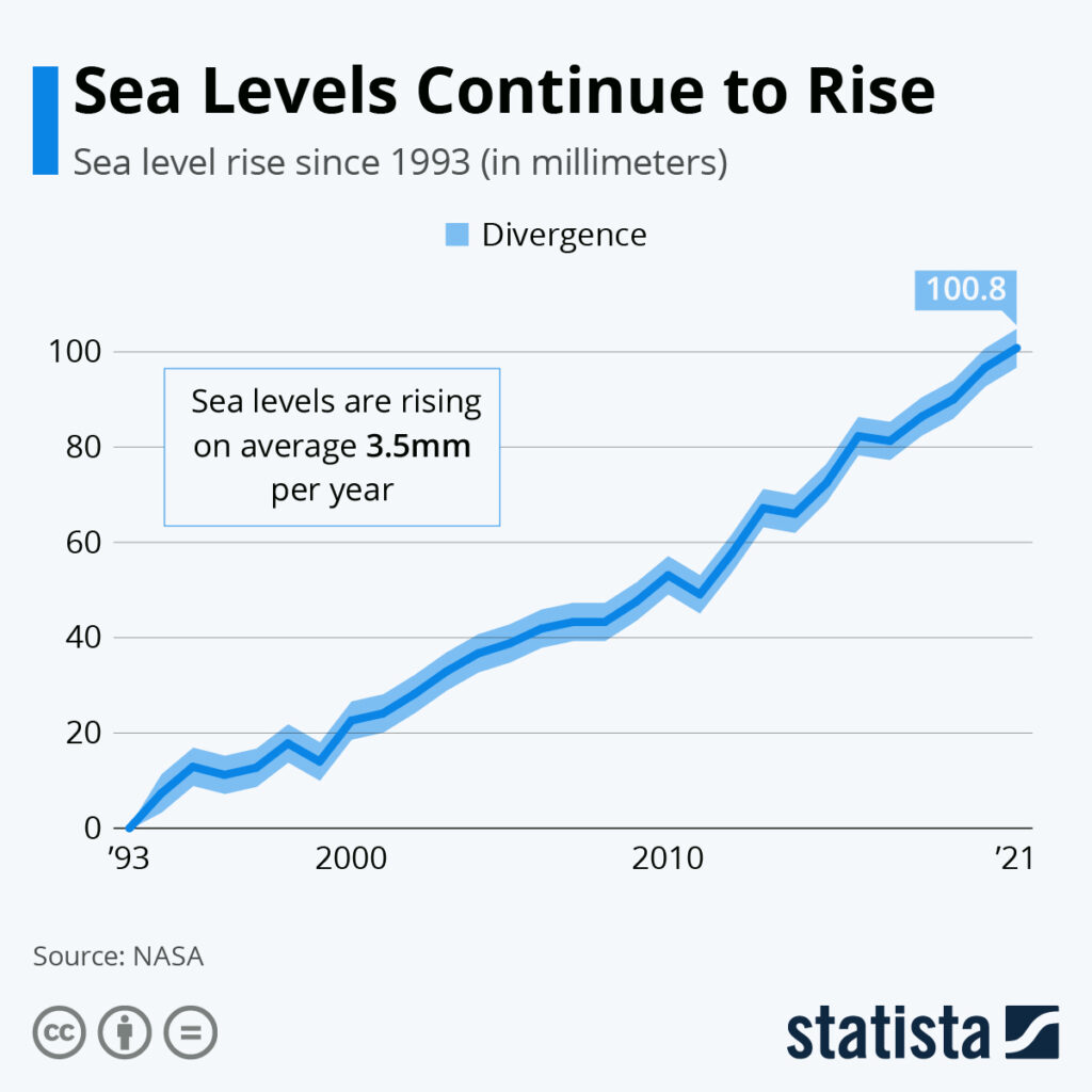
- Satellite altimetry (e.g., TOPEX/Poseidon, Jason‑3) records a global mean increase of 3.3 mm yr⁻¹ from 1993 to 2022 (NOAA, 2023).
- Tide‑gauge records along the Gulf Coast show relative rises of 2.5–4.0 mm yr⁻¹ after accounting for subsidence (NOAA, 2022).
- Ice‑sheet observations from NASA’s ICESat‑2 indicate accelerating mass loss in Greenland of ~280 Gt yr⁻¹ between 2010 and 2020 (NASA, 2021).
- Model ensembles used in the IPCC Sixth Assessment Report generate a 5‑95 percentile range of 0.84–1.00 m global SLR under RCP 8.5 by 2100, with higher regional values for the Gulf of Mexico due to subsidence.
These data sources are independent (satellite, ground, and model) and together provide strong confidence that sea level will continue to rise throughout the century.
Main Causes or Drivers
Direct Causes
- Atmospheric greenhouse‑gas concentrations exceeding pre‑industrial levels, driving ocean warming.
- Accelerated melt of the Greenland and Antarctic ice sheets.
Underlying Drivers
- Fossil‑fuel combustion and land‑use change that emit CO₂ and methane.
- Regional geological subsidence from sediment compaction and groundwater extraction.
Environmental and Human Impacts
Environmental Impacts
- Loss of coastal wetlands that serve as habitat for fish, birds, and as natural flood buffers.
- Increased salinity intrusion into freshwater marshes, altering plant communities.
- Higher frequency of “nuisance flooding” that can shift ecosystem dynamics.
Human Health and Social Impacts
- More frequent exposure to standing water raises risks of water‑borne diseases such as leptospirosis.
- Displacement of low‑income residents who often occupy the most flood‑prone neighborhoods, exacerbating social inequities.
- Psychological stress related to repeated flood events and uncertainty about long‑term habitability.
Economic and Infrastructure Impacts
- Levee overtopping or failure could cause catastrophic damage to residential and commercial districts.
- Higher baseline water levels increase pumping costs for the city’s drainage system, raising municipal budgets.
- Insurance premiums and property values in flood‑prone zones are projected to rise, affecting the local economy.
Regional Differences
Within the Greater New Orleans area, exposure varies:
- The Lower Ninth Ward and neighborhoods built on former river channels experience the greatest subsidence and thus the highest relative sea‑level rise.
- Uptown areas, built on older, more stable sediments, see somewhat lower relative rise but remain vulnerable to storm surge.
- Coastal parishes such as Plaquemines experience compounded risks from both sea‑level rise and coastal erosion.
What Scientists Know With High Confidence
What Scientists Know With High Confidence
- Global mean sea level has risen by about 20 cm since 1900, and the rate is accelerating.
- Thermal expansion and melting of land‑based ice are the two dominant contributors to observed sea‑level rise.
- New Orleans is sinking at 0.5–1 cm yr⁻¹, which adds to relative sea‑level rise.
- Higher baseline water levels increase the probability that a given storm will cause coastal flooding.
What Remains Uncertain
What Remains Uncertain
Key uncertainties include the rate at which the Antarctic ice sheet may destabilize, the exact magnitude of future greenhouse‑gas emissions, and how quickly local subsidence might accelerate under continued groundwater extraction. These uncertainties affect the upper bound of projected sea‑level rise but do not change the overall direction of change.
Common Misconceptions
Common Misconceptions
Misconception: Sea‑level rise will happen only if a massive storm hits.
Reality: Even without storms, the baseline water level will be higher, meaning “nuisance flooding” will occur during ordinary high tides.
Misconception: The city can simply raise its levees to any height.
Reality: Levee heightening faces engineering limits, cost constraints, and the risk of overtopping from larger storm surges.
Misconception: All sea‑level rise is caused by melting ice.
Reality: Thermal expansion of seawater accounts for roughly one‑third of observed rise; the rest is from ice melt and regional factors.
Solutions and Limitations
Adaptation strategies fall into three broad categories:
- Structural defenses: Elevating roads, retrofitting levees, and building floodwalls. These provide immediate protection but are expensive and may become insufficient under extreme scenarios.
- Nature‑based solutions: Restoring wetlands, planting marsh grasses, and creating living shorelines. These enhance water storage and biodiversity but require land availability and long‑term maintenance.
- Community‑level measures: Updating zoning codes, incentivizing elevated construction, and improving emergency response plans. Effectiveness depends on political will and equitable funding.
Each approach carries trade‑offs. For example, hard infrastructure can disrupt natural water flow, while wetland restoration may conflict with existing development interests.
What Individuals, Communities, and Governments Can Do
What Individuals Can Do
- Support local flood‑resilience initiatives, such as community‑run rain garden projects.
- Advocate for building‑code updates that require elevated foundations in flood‑prone zones.
- Reduce personal carbon footprints to help limit future emissions, acknowledging that individual actions are part of a broader societal effort.
What Communities and Organizations Can Do
- Partner with NGOs to restore and protect coastal wetlands that buffer storm surge.
- Develop neighborhood‑level emergency plans that include evacuation routes and resource distribution.
- Seek grant funding for green infrastructure such as permeable pavements and bioswales.
What Governments Can Do
- Invest in modernizing the levee system with adaptive designs that accommodate higher sea levels.
- Implement land‑use policies that limit new development in the most vulnerable low‑lying areas.
- Allocate federal and state funds for large‑scale wetland restoration and for retrofitting critical public facilities.
Closing Synthesis
Sea‑level rise in New Orleans by 2100 is a well‑documented phenomenon driven by global warming, ice‑sheet melt, and local subsidence. High‑confidence evidence shows that water levels will be higher, increasing flood risk and stressing infrastructure. Uncertainties remain in the exact magnitude of ice‑sheet contributions, but they do not overturn the overall trend. A mix of engineered defenses, nature‑based solutions, and proactive policy can reduce exposure, yet each strategy has limits that must be weighed against cost, equity, and ecological impact. Continued monitoring, equitable planning, and coordinated action are essential to safeguard New Orleans’ cultural heritage and its residents for generations to come.
Frequently Asked Questions
How much is sea level expected to rise in New Orleans by the end of the 21st century?
Projections show a rise of roughly 0.5 to 1.2 meters (1.6 to 4 feet) by 2100, depending on global emissions pathways and local land subsidence rates.
What are the main physical processes that cause sea‑level rise?
Sea‑level rise results from thermal expansion of warming ocean water, melting of glaciers and ice sheets, and regional factors such as land subsidence and ocean‑dynamic changes.
Which neighborhoods in New Orleans are most vulnerable to future flooding?
Low‑lying areas built on former river channels, such as the Lower Ninth Ward, experience the highest subsidence and therefore face the greatest relative sea‑level rise and flood risk.
What high‑confidence findings support the sea‑level projections for New Orleans?
Scientists are confident that global sea level has risen about 20 cm since 1900, thermal expansion and ice melt drive most of the rise, New Orleans is subsiding at 0.5–1 cm per year, and higher baseline water levels increase flood probability.
What actions can local governments take to reduce flood risk from rising seas?
Governments can modernize levees with adaptive designs, enforce land‑use policies that limit development in the most vulnerable zones, and fund large‑scale wetland restoration and infrastructure retrofits.





Leave a Comment