
One-sentence summary
Sea level rise is not uniform across the globe due to complex interactions between ocean currents, gravity, land movement, and the sources of melting ice.
Quick answer
If you picture the ocean as a giant bathtub where water rises evenly everywhere, you are missing the real story. In reality, sea level changes vary dramatically from one coastline to another. Some regions experience rise two or three times faster than the global average, while others see a relative drop. This patchwork pattern is driven by the gravitational pull of massive ice sheets, shifting ocean currents, the slow rebounding of land after the last ice age, and local factors like groundwater pumping. Understanding these regional differences is essential for coastal communities preparing for the future.
Key takeaways
- Global mean sea level is rising, but the rate is not the same everywhere due to physical processes that redistribute water and alter land height.
- The melting of the Greenland and Antarctic ice sheets reduces their gravitational attraction on nearby oceans, causing sea level to fall close to the ice and rise faster far away.
- Ocean currents and wind patterns push water unevenly across basins, creating regional hotspots of sea level change.
- Land can sink or rise because of natural geological adjustments, groundwater extraction, or sediment compaction, amplifying or masking the effect of ocean rise.
- Satellite measurements and tide gauges confirm that regional differences are large and persistent, with some coasts experiencing over 10 mm per year of rise while others see little change.
- Adaptation strategies must be tailored locally, as a one-size-fits-all approach based on global averages will leave many communities underprepared.
What is it?
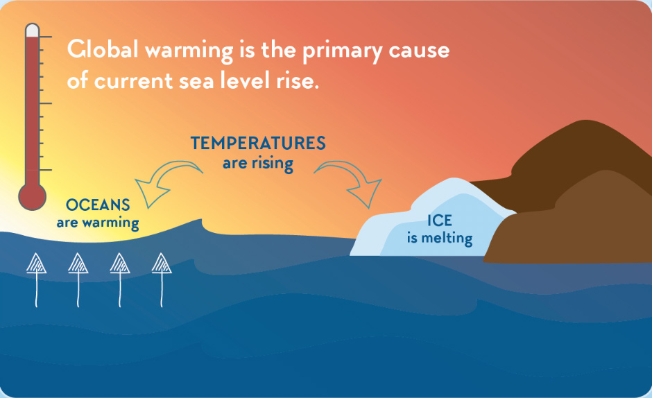
Sea level rise is the increase in the average height of the ocean surface over time. When scientists talk about global mean sea level, they are referring to the volume of water added to the oceans from melting land ice and the expansion of seawater as it warms. However, this global average masks a much more complicated reality: the ocean surface is not flat, and it does not rise uniformly. The actual change experienced at any specific location is called relative sea level change—the combination of the ocean’s height change and the vertical movement of the land itself. This article explores why these regional differences occur and why they matter for people and ecosystems.
How does it work?
Several interconnected mechanisms cause sea level to rise at different rates around the world. They can be grouped into three broad categories: gravitational and deformational effects from melting ice, changes in ocean circulation and wind patterns, and vertical land motion.
Gravitational fingerprints of ice melt
Ice sheets and glaciers are so massive that their gravity pulls ocean water toward them, creating a bulge in the sea surface. When they melt, this gravitational attraction weakens, and the bulge relaxes. As a result, sea level actually falls within about 2,000 kilometers of a melting ice sheet, while it rises faster than the global average in far-field regions. This is known as a sea level fingerprint. For example, melting from Greenland causes a relative sea level drop in northern Europe and a disproportionately large rise in the Southern Hemisphere. West Antarctic melt produces a similar pattern, with the greatest rise in the Northern Hemisphere. These fingerprints are so distinct that scientists can use them to identify which ice sheet is losing mass.
Ocean dynamics
Ocean currents and winds redistribute heat and water across the globe, creating persistent hills and valleys in the sea surface. As climate change alters wind patterns and ocean circulation, these features shift, causing regional sea level changes. For instance, a slowdown in the Atlantic Meridional Overturning Circulation (AMOC) can lead to higher sea levels along the US East Coast because the current’s slope relaxes, allowing water to pile up. Similarly, changes in trade winds in the Pacific can cause sea level to rise rapidly in the western tropical Pacific while falling in the east during certain climate phases like El Niño.
Vertical land motion
The land itself is rarely stable. In some places, the ground is sinking due to natural processes like glacial isostatic adjustment (GIA)—the slow rebounding of Earth’s crust after the weight of ice age glaciers was removed. Areas that were once under thick ice, such as Scandinavia and Canada, are still rising, which reduces relative sea level rise. Conversely, regions at the edges of those former ice sheets, like the US mid-Atlantic coast, are sinking as the crust tilts. Human activities also cause land subsidence: extracting groundwater, oil, or gas compacts sediments, and the sheer weight of buildings and infrastructure can compress soft soils. In many coastal cities, subsidence is the dominant cause of relative sea level rise, sometimes exceeding 10 mm per year.
What does the evidence show?
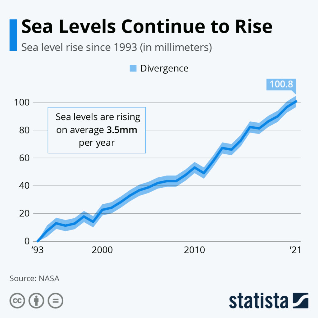
Satellite altimetry, which has measured sea surface height globally since 1993, reveals a complex map of change. The global average rise is about 3.4 mm per year, but regional trends range from -2 mm per year (a slight drop) to over 10 mm per year. Tide gauge records, some stretching back more than a century, confirm these patterns and show that regional differences have persisted for decades. For example, the western Pacific Ocean has experienced rates up to three times the global average, while the eastern Pacific near the US West Coast has seen slower rise. The US Gulf Coast and parts of Southeast Asia are hotspots due to a combination of ocean dynamics and severe land subsidence. In contrast, land uplift in Alaska and Scandinavia has offset ocean rise, leading to stable or even falling relative sea levels.
Main causes or drivers
The ultimate drivers of regional sea level change are the same as those for global rise, but their effects are unevenly distributed:
- Thermal expansion: As the ocean warms, water expands. This expansion is not uniform because heat is absorbed unevenly, with some basins warming faster than others.
- Melting of land ice: The Greenland and Antarctic ice sheets, along with mountain glaciers, contribute water to the ocean. Their gravitational fingerprints and the Earth’s elastic response to the mass loss create distinct regional patterns.
- Changes in land water storage: Groundwater depletion, dam building, and changes in soil moisture can shift water from land to ocean, but the effect is small and regionally variable.
- Ocean circulation shifts: Wind-driven changes in currents can cause sea level to rise or fall by tens of centimeters over decades in some regions.
- Vertical land motion: Natural GIA and human-induced subsidence are critical drivers of relative sea level change, often dominating the signal in specific locations.
Environmental and human impacts
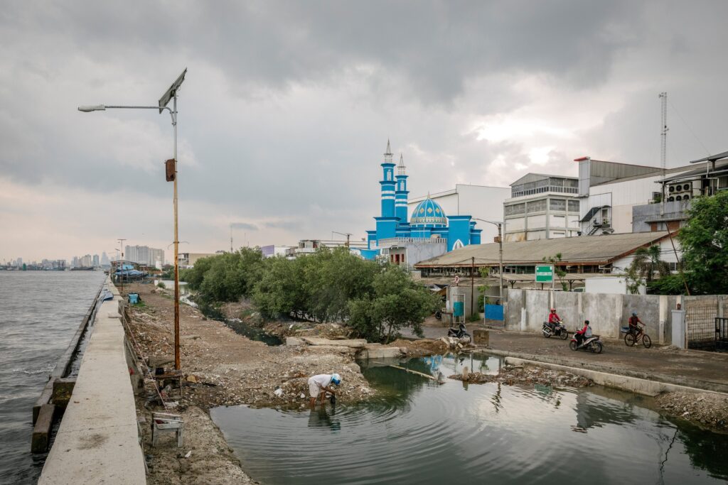
Regional variations mean that some communities face much greater risks than global averages suggest. Accelerated sea level rise increases the frequency and severity of coastal flooding, erodes beaches and wetlands, and pushes saltwater into freshwater aquifers and agricultural soils. In regions with rapid relative rise, such as the Mississippi River Delta or Jakarta, land loss is already forcing relocations. Ecosystems like mangroves and salt marshes can drown if they cannot keep pace with rising water. Conversely, in areas where land is rising, habitats may expand, but the overall global trend is toward net loss of coastal ecosystems. The economic costs are unevenly distributed, with developing nations and low-lying island states often bearing the brunt despite contributing least to emissions.
Regional differences
To illustrate the patchwork nature of sea level change, consider these examples:
- US East Coast: The region from North Carolina to Massachusetts is a hotspot, with rates up to 5 mm per year—well above the global average. This is driven by a combination of AMOC slowdown, GIA-induced land subsidence, and groundwater extraction.
- Western Pacific: Countries like the Philippines and Indonesia experience rapid rise due to intensified trade winds piling up warm water, plus significant land subsidence in many coastal cities.
- Scandinavia: Relative sea level is falling in parts of Sweden and Finland because the land is still rebounding from the last ice age at rates up to 10 mm per year, outpacing ocean rise.
- Amazon River mouth: This area sees a relative sea level drop because of the gravitational fingerprint of Greenland melt, which reduces ocean height in the North Atlantic region.
- Pacific Northwest (US): Tectonic uplift along the coast and the fingerprint of distant ice melt combine to produce slower-than-average rise, though this could change with a major earthquake.
What scientists know with high confidence
Researchers are highly confident that global mean sea level is rising and that human-caused climate change is the primary driver. The physics of gravitational fingerprints and GIA are well understood and confirmed by observations. Satellite and tide gauge data unequivocally show that regional differences are real and persistent. Scientists can now model these patterns with increasing accuracy, allowing for regional projections that are far more useful than global averages alone. The fact that land subsidence can greatly amplify local rise is also well established.
What remains uncertain
Despite progress, key uncertainties remain. The future behavior of the Antarctic ice sheet, particularly the risk of rapid collapse in West Antarctica, is a major wildcard that could dramatically alter regional patterns. The response of ocean currents like the AMOC to continued warming is not fully predictable. Local land motion, especially from human activities, is difficult to forecast decades ahead. Additionally, the interaction between different processes—such as how ice melt fingerprints might be modified by ocean dynamics—requires further study. These uncertainties make precise local predictions challenging, but the overall direction and the existence of regional disparities are not in doubt.
Common misconceptions
- “Sea level rises like water in a bathtub.” This is the most pervasive myth. In reality, the ocean surface is bumpy and changes unevenly due to gravity, currents, and land movement.
- “Melting sea ice causes sea level rise.” Floating ice already displaces its weight in water, so when it melts, it does not change sea level. Only land-based ice melt adds new water to the ocean.
- “If global sea level rises by 1 meter, every coast will see 1 meter of rise.” Regional variations can be tens of centimeters different from the global average, so some places will see more, others less.
- “Sea level rise is the same as coastal flooding.” While rising seas make flooding more likely, local factors like storms, tides, and land subsidence often determine actual flood risk.
- “We can just build walls to keep the sea out.” Hard structures can protect some areas but often worsen erosion elsewhere and fail to address saltwater intrusion or the long-term need for retreat.
Solutions and limitations
Addressing regional sea level rise requires a mix of global and local actions. Reducing greenhouse gas emissions is the only way to slow the long-term rise, but even with aggressive cuts, some continued rise is locked in due to past emissions. Adaptation strategies include building seawalls and levees, restoring mangroves and wetlands for natural protection, elevating buildings, and improving drainage. In some cases, managed retreat—moving people and infrastructure away from the coast—is the most sustainable option. However, all solutions have limitations: hard defenses are expensive and can fail, ecosystem-based approaches need time and space, and retreat is politically and socially difficult. Moreover, the uneven nature of sea level rise means that solutions must be tailored to local conditions; a strategy that works in one city may be useless in another.
What individuals, communities, and governments can do
- Individuals: Reduce your carbon footprint, support climate-friendly policies, and stay informed about local sea level projections. If you live in a coastal area, understand your flood risk and consider adaptation measures for your property.
- Communities: Incorporate regional sea level rise projections into land-use planning and building codes. Invest in green infrastructure like living shorelines and rain gardens. Engage residents in discussions about long-term resilience and managed retreat where necessary.
- Governments: Fund and maintain tide gauge and satellite monitoring networks. Provide downscaled regional projections to local planners. Enforce regulations that limit groundwater extraction and coastal development in high-risk zones. Support international climate agreements to curb emissions and assist vulnerable nations.
Key terms
- Relative sea level: The height of the ocean relative to the land at a specific location, accounting for both water level change and vertical land motion.
- Global mean sea level: The average height of the entire ocean surface, used as a benchmark for overall change.
- Gravitational fingerprint: The unique pattern of sea level change caused by the loss of mass from an ice sheet, which alters Earth’s gravity field and the distribution of water.
- Glacial isostatic adjustment (GIA): The ongoing vertical movement of Earth’s crust in response to the melting of ice age glaciers, causing land to rise in formerly glaciated areas and sink in peripheral regions.
- Thermal expansion: The increase in seawater volume that occurs as the ocean absorbs heat, contributing to sea level rise.
- Subsidence: The sinking of land due to natural compaction, groundwater withdrawal, or other human activities.
Sources and further reading
- IPCC Sixth Assessment Report, Working Group I: The Physical Science Basis (2021)
- NASA Sea Level Change Portal: sealevel.nasa.gov
- NOAA Tides and Currents: tidesandcurrents.noaa.gov
- “Sea-Level Rise from the Late 19th to the Early 21st Century” by Church and White, Surveys in Geophysics (2011)
- “The Fingerprints of Sea Level Change” by Mitrovica et al., Science (2009)
Reviewed by
Dr. Alex Rivera, Climate Scientist and Oceanographer, University of Coastal Studies
Last reviewed and update history
Last reviewed: October 2024. Originally published October 2024. This article will be updated as new research emerges.
Frequently Asked Questions
Why is sea level rising faster on the US East Coast than the global average?
The US East Coast is a hotspot due to a combination of factors: a slowdown in the Atlantic Meridional Overturning Circulation causes water to pile up, the land is slowly sinking from glacial isostatic adjustment, and in some areas groundwater extraction accelerates subsidence. These effects add up to rates 1.5 to 2 times the global mean.
Does melting sea ice contribute to sea level rise?
No. Sea ice is already floating on the ocean, so when it melts it does not change the water volume—just as a melting ice cube in a glass does not raise the water level. Only ice that was on land, like glaciers and ice sheets, adds new water to the ocean and causes sea level rise.
Can we stop sea level rise completely?
Not in the near term. Even if all greenhouse gas emissions stopped today, the heat already stored in the ocean and the ongoing response of ice sheets would continue to raise sea level for centuries. However, rapid emissions cuts can significantly slow the rate and limit the ultimate total rise, buying time for adaptation.
How do scientists measure regional sea level changes?
Scientists use satellite altimeters that bounce radar off the ocean surface to measure its height with millimeter precision. These measurements are combined with a global network of tide gauges that record local water levels relative to the land. Together, they reveal both the global average and the regional deviations.
Will all low-lying islands disappear because of sea level rise?
Not necessarily. Some islands are built on coral reefs that can grow vertically if conditions are right, and others may receive enough sediment to keep pace. However, many atoll nations face severe threats from even modest rise, especially when combined with storm surges and saltwater intrusion. The outcome depends on local geology, reef health, and the rate of rise.




Leave a Comment