
The East Coast won’t disappear beneath the ocean this century, but combined global sea‑level rise and regional land subsidence will make “sunny‑day” flooding increasingly common, and science‑based projections guide how societies can adapt.
Quick Answer
The ocean is rising about 3–4 mm per year globally, and many East Coast areas are sinking up to 10 mm per year, so relative sea level rises faster than the global average. The Intergovernmental Panel on Climate Change projects a global increase of 0.3–1.1 m by 2100, and local subsidence can add a few centimeters more. Consequently, cities such as New York, Miami, and Charleston will face frequent tidal flooding, but complete submergence of the coastline is not supported by current models.
Key Takeaways
- Global sea‑level rise averages 3–4 mm yr⁻¹, driven by thermal expansion and ice‑sheet melt.
- Land subsidence—up to 10 mm yr⁻¹ in some river deltas—accelerates local relative sea‑level rise.
- All major East Coast metros will see more frequent “sunny‑day” floods within decades.
- Full submergence of the coastline by 2100 is not supported by high‑confidence scientific assessments.
- Adaptation options (elevated infrastructure, wetland restoration, managed retreat) reduce exposure but involve cost and equity trade‑offs.
What Is Will the East Coast Really Be Underwater? What Science Actually Predicts?
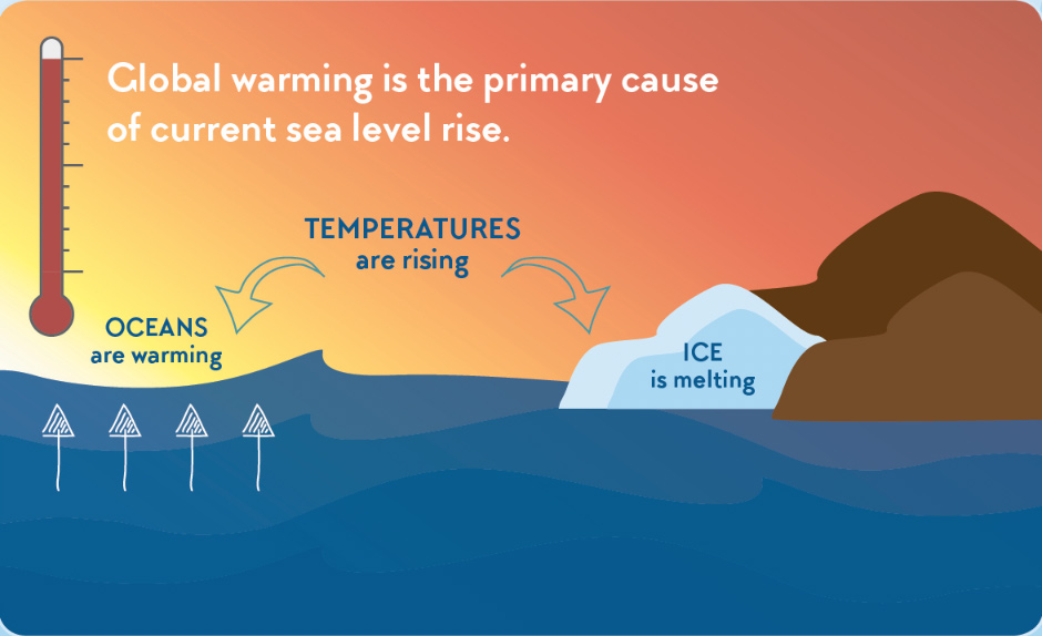
The phrase combines two linked concepts: (1) the long‑term rise of global sea level caused by a warming climate, and (2) regional land subsidence that makes local water levels climb faster than the global average. Together they determine “relative sea level,” the height of the ocean relative to the land on which people live. Understanding this interaction is essential for coastal planning, risk assessment, and policy making.
How Does It Work?
1. Global Sea‑Level Rise
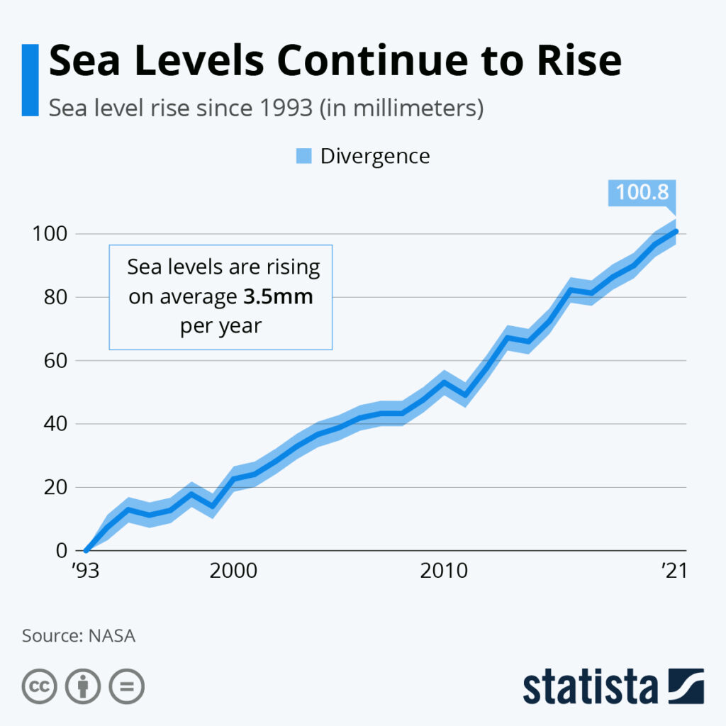
Warmer ocean water expands (thermal expansion) and melting glaciers and the Greenland and Antarctic ice sheets add water to the oceans. Satellite altimetry from NASA and ESA shows a near‑linear increase of roughly 3.3 mm yr⁻¹ since 1993 (NOAA, 2023).
2. Land Subsidence
Subsidence occurs when the ground surface sinks. On the East Coast three processes dominate:
- Glacial isostatic adjustment – the Earth’s crust is still rebounding from the last Ice Age, causing some coastal basins to sink.
- Groundwater extraction – pumping lowers aquifer pressure, allowing sediments to compact.
- Urban loading – the weight of buildings, roads, and fill compresses underlying sediments.
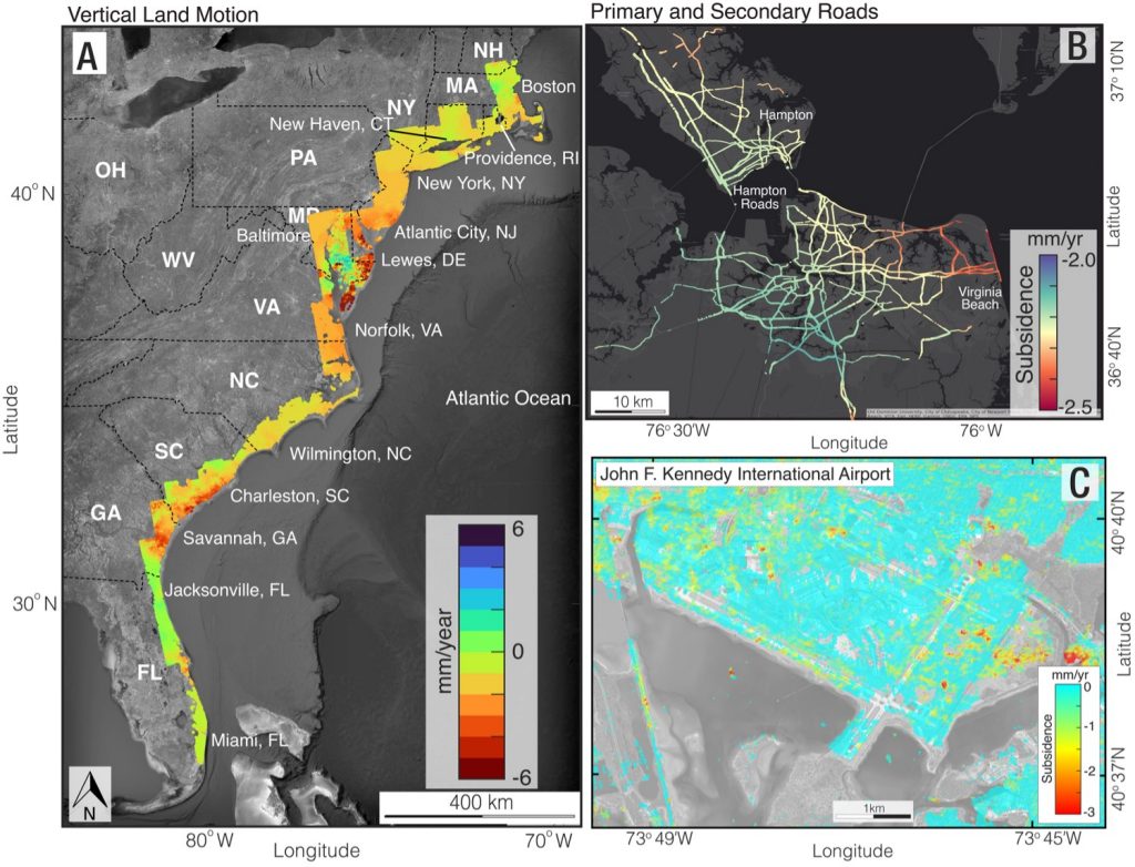
U.S. Geological Survey measurements show subsidence up to 5 mm yr⁻¹ in the Chesapeake Bay region and rates exceeding 10 mm yr⁻¹ in parts of the Florida coast.
3. Interaction and Feedbacks
When sea level rises and land sinks simultaneously, the relative increase is roughly additive, amplifying tidal ranges, eroding protective shorelines, and altering groundwater salinity. These feedbacks can accelerate coastal erosion and increase flood risk.
What Does the Evidence Show?
Multiple independent lines of evidence converge on the same conclusion:
- Tide‑gauge records from NOAA document a mean rise of about 2.5 mm yr⁻¹ along the Mid‑Atlantic since the early 20th century after correcting for subsidence.
- Satellite gravimetry (GRACE mission) confirms accelerated ice‑sheet loss, especially from Greenland, supporting higher future sea‑level scenarios.
- Geodetic measurements (GPS and InSAR) map subsidence hotspots, showing rates of 2–12 mm yr⁻¹ in urban basins such as New York City and Tampa Bay.
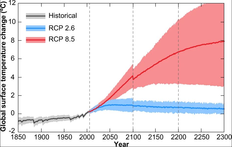
- The IPCC Sixth Assessment Report (2021) gives a high‑confidence global sea‑level rise range of 0.28–1.01 m by 2100 under low‑ and high‑emission pathways.
- Regional modelling (e.g., NOAA’s Sea Level Rise Viewer) that combines global rise with local subsidence projects “annual flood” conditions for many Northeast locations by 2050 even under the low‑emission scenario.
These observations indicate that while the ocean will continue to climb, local land movement can double the effective rise in some hotspots.
Main Causes or Drivers
Direct Causes
- Thermal expansion of seawater due to atmospheric warming.
- Mass loss from glaciers and the Greenland and Antarctic ice sheets.
- Land subsidence from isostatic adjustment, groundwater withdrawal, and urban loading.
Underlying Drivers
- Rising greenhouse‑gas concentrations from fossil‑fuel combustion.
- Population growth and coastal development that intensify groundwater extraction.
- Long‑term ice‑sheet dynamics set by past climate variability.
Environmental and Human Impacts
Environmental Impacts
- Accelerated shoreline erosion reduces habitat for marshes, oysters, and nesting birds.
- Saltwater intrusion into freshwater aquifers threatens drinking‑water supplies and agricultural soils.
- Loss of coastal wetlands diminishes carbon sequestration capacity and biodiversity.
Human Health and Social Impacts
- Frequent flooding increases exposure to mold, vector‑borne diseases, and mental‑health stress.
- Low‑income neighborhoods often occupy the most flood‑prone zones, amplifying environmental injustice.
- Displacement risk grows as properties become repeatedly uninhabitable.
Economic and Infrastructure Impacts
- Storm‑water pumps, roadways, and subway systems in cities like New York face rising maintenance costs.
- Property values in high‑risk zones can decline, affecting tax bases and insurance markets.
- Tourism and fisheries suffer when beaches erode or water quality declines.
Regional Differences
East Coast conditions vary widely:
- Northeast (New York, Boston): Subsidence rates modest (1–3 mm yr⁻¹), but dense urban infrastructure makes adaptation costly.
- Mid‑Atlantic (Chesapeake Bay, Philadelphia): Combined sea‑level rise and subsidence up to 5 mm yr⁻¹ create some of the fastest relative rises in the nation.
- Southeast (Miami, Charleston): High subsidence (up to 10 mm yr⁻¹) and low‑lying topography lead to chronic “sunny‑day” flooding already observed during king tides.
These patterns mean that mitigation and adaptation strategies must be tailored to local rates of relative sea‑level change.
What Scientists Know With High Confidence
- Global mean sea level has risen and will continue to rise as long as atmospheric greenhouse‑gas concentrations remain elevated.
- Land subsidence contributes significantly to relative sea‑level rise in many East Coast locales.
- All major East Coast cities will experience increased frequency of tidal flooding within the next few decades.
- Restoring coastal wetlands can reduce flood heights by 10–30 % in many settings (peer‑reviewed meta‑analyses).
What Remains Uncertain
Key uncertainties include the exact contribution of the Greenland and Antarctic ice sheets to sea‑level rise, future trajectories of regional subsidence under changing groundwater policies, and the socioeconomic pathways that will determine how aggressively communities invest in adaptation. Improved satellite monitoring and expanded GPS networks are expected to narrow these gaps over the next decade.
Common Misconceptions
Misconception: The entire East Coast will be underwater by 2100.
Reality: Scientific assessments show that while flooding will become more frequent, complete submergence of the coastline is not supported by current models.
Misconception: Sea‑level rise is the only reason for coastal flooding.
Reality: Land subsidence, storm surge, and tidal dynamics all combine with sea‑level rise to determine local flood risk.
Misconception: Building higher sea walls will solve the problem.
Reality: Hard engineering can protect specific assets but often shifts risk elsewhere, incurs high costs, and may damage natural habitats.
Solutions and Limitations
Response strategies fall into three broad categories:
- Adaptation – elevating roads, installing pump stations, and implementing managed retreat. These actions reduce immediate exposure but can be expensive and raise equity concerns if vulnerable communities are displaced.
- Nature‑Based Solutions – restoring mangroves, saltmarshes, and barrier islands. They provide flood attenuation and ecological co‑benefits, yet require sufficient space, long‑term maintenance, and may be limited by development pressure.
- Mitigation – reducing greenhouse‑gas emissions slows future sea‑level rise. While essential, mitigation alone will not eliminate near‑term flooding caused by existing sea‑level rise and subsidence.
What Individuals, Communities, and Governments Can Do
What Individuals Can Do
- Support local ordinances that limit groundwater extraction and promote green infrastructure.
- Participate in community flood‑mapping efforts to improve local risk data.
- Choose resilient housing designs—elevated foundations or flood‑proof utilities—when building or renovating.
What Communities and Organizations Can Do
- Develop and regularly update municipal flood‑risk assessments that incorporate both sea‑level rise and subsidence data.
- Invest in wetland restoration projects that buffer storm surge and improve water quality.
- Create equitable relocation plans that prioritize low‑income residents and preserve cultural heritage.
What Governments Can Do
- Adopt science‑based sea‑level rise scenarios (e.g., NOAA’s intermediate and high pathways) in zoning and building codes.
- Fund regional GPS and InSAR networks to monitor subsidence in near real‑time.
- Allocate federal and state disaster‑relief resources to support large‑scale adaptation projects, such as the East Coast Resilience Initiative.
Closing Synthesis
The East Coast’s future will be shaped by the interplay of rising oceans and sinking land. High‑confidence science confirms that flooding will become more common, especially in low‑lying cities, but the notion of the entire coastline disappearing under water is not supported by current evidence. Uncertainties remain around ice‑sheet dynamics and local subsidence trends, underscoring the need for continued monitoring. By combining mitigation, nature‑based adaptation, and equitable policy, societies can reduce exposure and protect both communities and ecosystems for generations to come.
Frequently Asked Questions
What is relative sea level and how is it measured?
Relative sea level is the height of the ocean surface compared to the land on which people live. It is measured using tide‑gauges, satellite altimetry, and GPS or InSAR data that capture both water height and land movement.
How fast is sea level rising along the U.S. East Coast?
Along the East Coast, tide‑gauge records show a mean rise of about 2.5 mm per year since the early 1900s after accounting for subsidence. Satellite data indicate a global average of 3–4 mm per year since the 1990s, which adds to local rates.
Will any major East Coast city be completely submerged by 2100?
No major East Coast city is projected to be completely underwater by 2100. Scientific assessments indicate increased flooding frequency, but high‑confidence models do not support full submergence of the coastline within this century.
What are the main reasons for land subsidence on the East Coast?
Land subsidence on the East Coast is driven by glacial isostatic adjustment (the crust still rebounding from the last Ice Age), groundwater extraction that compacts sediments, and the weight of urban development compressing underlying soils.
What actions can individuals take to help reduce flood risk on the East Coast?
Individuals can support policies that limit groundwater pumping, join local flood‑mapping projects, and choose resilient home designs such as elevated foundations or flood‑proof utilities. These steps complement broader community and governmental adaptation efforts.





Leave a Comment