
A one‑meter rise in global sea level would reshape coastlines, threaten millions of people, alter ecosystems, and demand large‑scale adaptation, but the science behind the projection is well documented.
Quick Answer
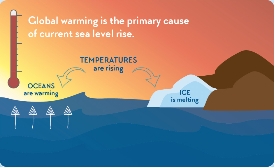
A one‑meter increase in average sea level means that any land currently less than one meter above today’s high tide would become regularly inundated. The rise results from thermal expansion of warming ocean water and added water from melting glaciers and the Greenland and Antarctic ice sheets, as shown by the Intergovernmental Panel on Climate Change (IPCC) Fifth Assessment Report (2014) and subsequent updates. Scientists are confident that continued greenhouse‑gas emissions will push global sea level beyond a meter by the end of this century under high‑emission scenarios, though exact timing varies. The most immediate impact will be chronic coastal flooding, loss of low‑lying habitats, and heightened storm‑surge risk.
Key Takeaways
- One meter of sea‑level rise would permanently flood roughly 150 million people living within 1 m of current coastlines.
- Thermal expansion and ice‑sheet melt together drive the rise, with the latter contributing about two‑thirds of recent acceleration.
- Impacts differ by region because of land subsidence, ocean currents, and local topography.
- High‑confidence findings include the mechanisms of rise and the vulnerability of coastal wetlands.
- Uncertainties remain in the rate of Antarctic ice‑sheet loss and in how quickly societies can implement large‑scale adaptation.
What Is a 1‑Meter Sea Level Rise?
A one‑meter sea‑level rise (SLR) refers to a global‑average increase of 1 m (approximately 3.3 ft) in the height of the ocean’s surface relative to a fixed land datum. It is expressed as an average because local sea level can be higher or lower due to regional factors such as land uplift, subsidence, or oceanographic variations. The term differs from short‑term storm surge, which is a temporary rise caused by a specific weather event, and from “relative sea‑level rise,” which adds local land movement to the global signal.
How Does Sea Level Rise Occur?
Thermal Expansion
When seawater warms, its volume expands. Satellite altimetry from NASA’s Jason‑3 mission shows that thermal expansion accounted for about 30 % of the 0.20 m global rise observed between 1900 and 2018 (NOAA, 2020).
Ice‑Sheet and Glacier Melt
Melting of mountain glaciers, the Greenland Ice Sheet, and the West Antarctic Ice Sheet adds water directly to the oceans. The IPCC (2021) estimates that ice‑sheet contributions increased from 0.07 m to 0.12 m over the past two decades, accelerating the overall trend.
Land‑Water Interactions
Groundwater extraction and reservoir storage can temporarily raise sea level when extracted water eventually returns to the ocean. Conversely, sediment deposition in deltas can offset local rise but is often outpaced by subsidence.
What Does the Evidence Show?
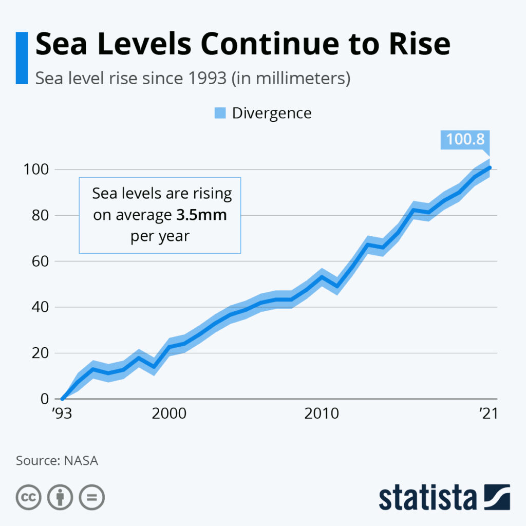
Multiple lines of evidence converge on a clear upward trend. Tide‑gauge records, now covering more than 200 years of observations, document a rise of roughly 0.19 m since 1900 (WCRP, 2020). Satellite measurements, beginning in 1992, confirm a rate of about 3.3 mm yr⁻¹, with a slight acceleration in the past decade (NASA, 2022). Paleoclimatic reconstructions, such as coral reef terraces, reveal that the last interglacial period (≈125 ka) saw sea levels 5–9 m higher, demonstrating that the climate system can produce much larger rises under sustained warming.
Main Causes or Drivers
Human‑Induced Climate Change
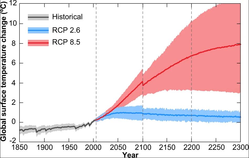
Anthropogenic greenhouse‑gas emissions increase atmospheric temperatures, driving both thermal expansion and ice melt. The IPCC attributes more than 90 % of the observed warming since 1950 to human activities.
Natural Variability
Long‑term oceanic cycles, such as the Pacific Decadal Oscillation, can cause decade‑scale sea‑level fluctuations, but they are superimposed on the longer, monotonic rise caused by warming.
Land Motion
Subsidence from sediment compaction, oil extraction, or tectonic activity can amplify relative sea‑level rise locally, making some areas experience more than the global average.
Environmental and Human Impacts
Environmental Impacts
- Coastal Wetlands: Salt‑marsh and mangrove habitats will migrate landward where space permits, but many will be lost where development blocks this retreat, reducing natural storm buffers.
- Biodiversity: Species that rely on narrow intertidal zones, such as certain shorebirds and nesting turtles, face habitat loss and population declines.
- Carbon Sequestration: Wetland loss diminishes blue‑carbon storage, creating a feedback that can modestly increase atmospheric CO₂.
Human Health and Social Impacts
- Increased exposure to salt‑water intrusion can contaminate freshwater supplies, raising risks of water‑borne disease.
- Displacement of up to 150 million people (UN‑Habitat, 2022) would intensify migration pressures and stress urban infrastructure.
- Low‑income coastal communities often lack resources for large‑scale protection, amplifying social inequities.
Economic and Infrastructure Impacts
- Property values in flood‑prone zones can decline by 10‑30 % per meter of projected rise (World Bank, 2021).
- Critical infrastructure—roads, ports, power plants—may require costly elevation or relocation, with global adaptation costs estimated at $1 trillion per meter of rise (IPCC, 2021).
Regional Differences
Because sea‑level rise is not uniform, impacts vary. In the Gulf of Mexico, subsidence adds 0.3‑0.5 m to the global mean, making Miami and New Orleans especially vulnerable. In contrast, parts of the Pacific Northwest experience lower relative rise due to tectonic uplift. Low‑lying delta regions such as the Mekong, Ganges‑Brahmaputra, and Nile already see elevations below one meter and therefore face near‑immediate inundation, while high‑latitude Arctic coasts may experience slower relative rise but greater permafrost melt effects.
What Scientists Know With High Confidence
- Global mean sea level has risen by about 0.20 m since 1900, with an accelerating rate.
- Thermal expansion and ice‑sheet melt are the primary physical mechanisms.
- Coastal populations are disproportionately exposed to flood risk.
- Wetland loss reduces natural storm protection and carbon storage.
What Remains Uncertain
Key uncertainties include the future rate of West Antarctic Ice Sheet discharge, which depends on poorly understood ice‑ocean interactions, and the socioeconomic pathways that will determine emission trajectories. Regional projections are also limited by sparse tide‑gauge coverage in many developing coastal zones, making precise local forecasts difficult.
Common Misconceptions
Misconception: Sea‑level rise is only a distant future problem.
Reality: The past two decades have already seen a measurable acceleration, and many low‑lying communities are experiencing chronic flooding today.
Misconception: All coastlines will rise exactly one meter.
Reality: Local relative sea‑level change can be higher or lower due to land movement, ocean currents, and gravitational effects of melting ice.
Misconception: Building seawalls solves the problem.
Reality: Hard defenses protect specific assets but can exacerbate erosion elsewhere, are costly, and do not address the underlying drivers of rise.
Solutions and Limitations
Effective responses combine mitigation (reducing greenhouse‑gas emissions) with adaptation (protecting and relocating at‑risk communities). Nature‑based solutions such as restoring mangroves and dunes can attenuate wave energy, but they require sufficient land and may be overwhelmed by extreme events. Managed retreat—planned relocation of infrastructure—offers long‑term resilience but faces political, cultural, and financial barriers. Large‑scale engineering, like elevated roadways, provides localized safety but does not reduce exposure for unprotected areas.
What Individuals, Communities, and Governments Can Do
What Individuals Can Do
- Support policies that set ambitious net‑zero targets to curb future warming.
- Participate in local coastal‑restoration projects, such as planting native marsh grasses.
- Consider flood‑risk information when purchasing coastal property.
What Communities and Organizations Can Do
- Develop and implement community‑wide adaptation plans that include zoning changes and early‑warning systems.
- Invest in green infrastructure—living shorelines, oyster reefs, and dune reinforcement—to provide natural buffers.
- Secure financing mechanisms (e.g., climate resilience bonds) to fund large‑scale relocation where retreat is unavoidable.
What Governments Can Do
- Adopt and enforce building codes that require elevation of new structures in flood‑prone zones.
- Allocate national budgets for climate‑smart infrastructure and for assisting displaced populations.
- Integrate sea‑level projections into urban‑planning, transport, and energy‑system models to avoid maladaptive investments.
Closing Synthesis
A one‑meter sea‑level rise is not a hypothetical scenario; it is a scientifically documented trajectory driven by warming oceans and melting ice. High‑confidence evidence shows that millions will face permanent flooding, ecosystem loss, and heightened economic strain, while uncertainties remain around the speed of Antarctic ice loss and the effectiveness of large‑scale adaptation. By combining rapid emissions reductions with strategic, equity‑focused adaptation—especially nature‑based solutions and managed retreat—societies can mitigate the most severe outcomes and preserve coastal livelihoods for future generations.
Frequently Asked Questions
How is a one‑meter sea‑level rise measured?
Scientists measure sea‑level rise using tide‑gauge records anchored to the land and satellite altimetry that tracks the ocean surface globally. The average increase of about 0.20 m since 1900 is derived from these combined observations.
What are the main physical processes that cause sea‑level rise?
Thermal expansion of warming seawater and the addition of meltwater from glaciers, the Greenland Ice Sheet, and the Antarctic Ice Sheet are the two primary processes driving global sea‑level rise.
Which regions would be most affected by a one‑meter rise?
Low‑lying delta regions such as the Mekong, Ganges‑Brahmaputra, and Nile, as well as heavily populated coastlines like Miami, New Orleans, and parts of Bangladesh, would face the most immediate and severe impacts.
What are the biggest uncertainties in predicting future sea‑level rise?
The rate of West Antarctic Ice Sheet melt and future socioeconomic pathways that determine greenhouse‑gas emissions are the largest sources of uncertainty, affecting both the magnitude and timing of projected rise.
Can building seawalls fully protect coastal cities from a one‑meter rise?
Seawalls can protect specific assets but do not stop overall sea‑level rise, can be costly, and may cause increased erosion elsewhere. Comprehensive adaptation requires a mix of hard defenses, nature‑based solutions, and managed retreat.





Leave a Comment