
Atmospheric Rivers Explained: Earth’s Most Powerful Storm Systems
Atmospheric rivers are long, narrow corridors of extreme moisture that move from the tropics toward mid‑latitude regions, shaping weather, water resources, and flood risk worldwide.
Quick Answer
Atmospheric rivers are elongated bands of water vapor—often several thousand kilometres long and up to a few hundred kilometres wide—that transport moisture from tropical oceans toward higher latitudes, where they release rain or snow. Driven primarily by the mid‑latitude jet stream, these rivers can carry more water than the Mississippi River and are a key component of the global hydrological cycle. Their impacts range from vital water‑supply replenishment to severe flooding, and scientific evidence indicates that a warming climate may increase their intensity, although exact future changes remain uncertain.
Key Takeaways
- Atmospheric rivers move massive amounts of water vapor, comparable to the flow of the Mississippi River.
- They are steered by the jet stream and are most common on the west coasts of continents.
- Both beneficial (snowpack, water supply) and hazardous (floods, landslides) impacts are documented.
- Climate‑model studies suggest a likely increase in moisture content and extreme events.
- Improved monitoring and forecasting can reduce societal risk.
What Is Atmospheric Rivers Explained: Earth’s Most Powerful Storm Systems?
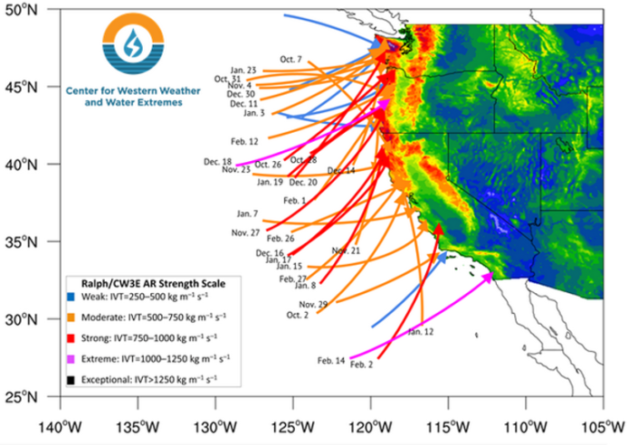
An atmospheric river (AR) is a narrow, elongated corridor of high water‑vapor content in the lower to middle troposphere. Typical ARs are 200–400 km wide, 2 000–5 000 km long, and can transport 2–5 × 10⁸ kg day⁻¹ of water—roughly the average discharge of the Mississippi River (NOAA, 2020). The term distinguishes these features from ordinary moist airstreams by their coherent structure, high integrated water vapor (IWV), and ability to produce intense precipitation when forced over terrain. ARs are most frequently identified over the Pacific Ocean, where they are sometimes called “Pineapple Express” when originating near Hawaii.
How Does It Work?
Formation over warm oceans
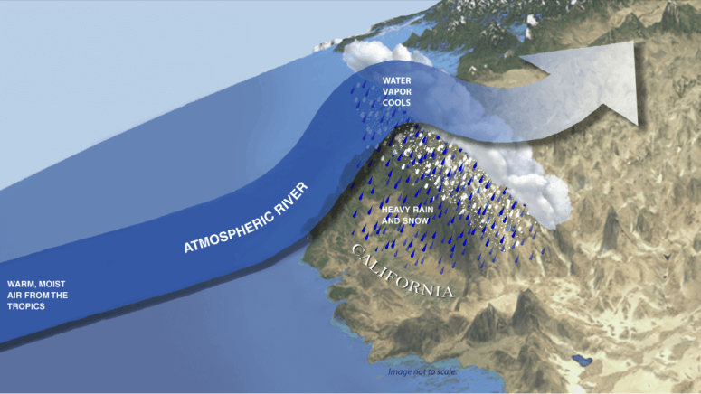
Warm sea‑surface temperatures (≥ 27 °C) cause rapid evaporation, injecting large amounts of water vapor into the boundary layer. Convergence zones and mid‑latitude cyclones lift this moist air, creating a plume that aligns with the jet stream.
Transport by the jet stream
The strong westerly jet stream acts as a conveyor belt, channeling the vapor‑laden plume thousands of kilometres. Potential vorticity and upper‑level wave patterns determine the AR’s trajectory.
Release over topography
When an AR encounters elevated terrain—such as the Sierra Nevada or the Cascades—the air is forced upward (orographic lift). Cooling leads to condensation and heavy precipitation, often as snow at higher elevations.
Feedbacks and dissipation
Latent‑heat release during condensation can intensify the local circulation, sometimes extending the AR’s lifespan. Eventually, the moisture is exhausted, and the AR weakens.
What Does the Evidence Show?
Long‑term satellite observations (e.g., AIRS, MODIS) combined with reanalysis data show that ARs account for 30–50 % of total poleward water transport in the mid‑latitude Pacific (IPCC AR6, 2021). Ground‑based rain‑gauge networks confirm that a single AR can deliver > 300 mm of rain in 24 hours, comparable to a major flood event (NOAA, 2022). Model intercomparison projects (CMIP6) indicate a robust increase in atmospheric moisture capacity of ~7 % per °C of warming, suggesting stronger ARs in a 1.5 °C warmer world (IPCC, 2021). However, the frequency of AR occurrence shows mixed signals across studies, reflecting regional variability and limited historical records.
Main Causes or Drivers
Natural drivers
- Sea‑surface temperature gradients that fuel evaporation.
- Mid‑latitude jet‑stream dynamics that steer moisture.
- Large‑scale atmospheric waves (Rossby waves) that create favorable pathways.
Human influences
- Global warming raises atmospheric water‑holding capacity, potentially intensifying AR moisture content.
- Changes in land‑use and aerosol emissions can modify regional temperature gradients, subtly affecting jet‑stream patterns.
Environmental and Human Impacts
Environmental Impacts
ARs deliver essential snowpack to the Sierra Nevada, sustaining California’s reservoirs and downstream ecosystems. Conversely, extreme events can cause landslides, riverbank erosion, and habitat disruption.
Human Health and Social Impacts
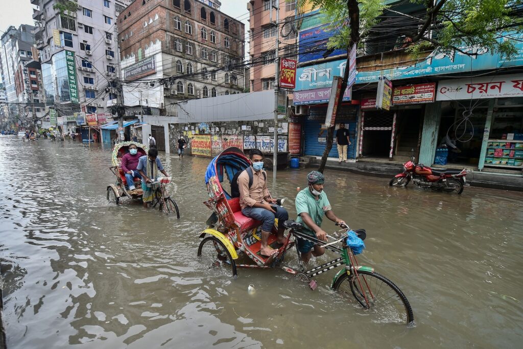
Heavy rainfall can overwhelm storm‑water systems, leading to property damage, displacement, and water‑borne disease risk. Communities with limited flood protection are disproportionately affected.
Economic and Infrastructure Impacts
In the United States, AR‑related floods have caused billions of dollars in damage in events such as the 2017 California floods (U.S. FEMA, 2018). At the same time, the water supplied by ARs supports agriculture worth over $30 billion annually in the western U.S. (USDA, 2020).
Regional Differences
On the West Coast of North America, ARs commonly bring winter precipitation that replenishes snowpack. In contrast, the U.K. experiences ARs less frequently, but when they occur they can cause flash floods, as observed in the 2015 “Storm Desmond” event (Met Office, 2015). In the Southern Hemisphere, ARs over the South Pacific are less studied, and their contribution to the water cycle remains an active research area.
What Scientists Know With High Confidence
- Atmospheric rivers are a major conduit of poleward moisture transport.
- They are closely linked to the jet stream and orographic lift.
- Warmer air holds more water vapor, implying that a warming climate can increase AR intensity.
- ARs are responsible for a large fraction of precipitation in many mid‑latitude coastal regions.
What Remains Uncertain
Key uncertainties include the projected change in AR frequency, the exact thresholds at which AR‑related flooding becomes catastrophic, and how land‑use changes may interact with AR dynamics. Limited historical observations, especially over oceans, constrain model validation, making it difficult to separate natural variability from climate‑driven trends.
Common Misconceptions
Misconception: Atmospheric rivers are the same as hurricanes.
Reality: Hurricanes are cyclonic storms with a warm core and organized rotation, whereas atmospheric rivers are linear moisture corridors without a closed circulation.
Misconception: All atmospheric rivers cause floods.
Reality: Many ARs deliver moderate rainfall that recharges soils and snowpacks without causing flooding; impacts depend on antecedent conditions and terrain.
Misconception: Climate change will eliminate atmospheric rivers.
Reality: Climate warming is expected to increase the moisture capacity of ARs, not remove them; the risk is a shift toward more intense events.
Solutions and Limitations
Effective responses combine improved forecasting, resilient infrastructure, and ecosystem‑based management. Early‑warning systems using satellite‑derived IWV and ensemble weather models have reduced flood losses by up to 30 % in some U.S. basins (NOAA, 2021). However, forecasting remains uncertain beyond 5–7 days, and building higher levees can exacerbate downstream risk. Restoring wetlands and floodplains can attenuate runoff, yet land‑availability and funding constraints limit large‑scale implementation.
What Individuals, Communities, and Governments Can Do
What Individuals Can Do
- Support local watershed restoration projects that increase natural flood storage.
- Use rain‑water capture systems to reduce demand on municipal supplies that rely on AR precipitation.
- Stay informed about AR forecasts through official meteorological services.
What Communities and Organizations Can Do
- Incorporate AR risk maps into land‑use planning and building codes.
- Invest in green infrastructure such as permeable pavements and urban wetlands.
- Develop community emergency response plans that account for rapid‑onset flooding.
What Governments Can Do
- Fund research and operational monitoring of atmospheric rivers (e.g., satellite IWV products).
- Implement adaptive water‑management policies that balance flood control with water‑storage needs.
- Provide subsidies or incentives for retrofitting critical infrastructure to withstand AR‑related floods.
Synthesizing the Knowledge
Atmospheric rivers are a natural, powerful component of Earth’s climate system, moving vast quantities of water vapor from the tropics to mid‑latitudes. Robust evidence confirms their role in regional water budgets and flood risk, while climate warming is likely to make the most extreme events stronger. Uncertainties remain around frequency changes and precise flood thresholds, underscoring the need for better observations and models. By integrating improved forecasting, resilient infrastructure, and nature‑based solutions, societies can harness the benefits of atmospheric rivers while reducing their hazards.
Frequently Asked Questions
What exactly is an atmospheric river?
An atmospheric river is a narrow, elongated band of high water‑vapor content in the lower to middle troposphere, often thousands of kilometres long and a few hundred kilometres wide, that transports large amounts of moisture from tropical oceans toward higher latitudes.
How do atmospheric rivers form and move across the globe?
They form over warm ocean waters where evaporation injects moisture into the air; mid‑latitude cyclones and the jet stream then lift and steer this moist plume, sometimes for thousands of kilometres, until it encounters terrain that forces it upward and releases the water as rain or snow.
Why are atmospheric rivers important for water resources?
Atmospheric rivers deliver a significant share of precipitation to many mid‑latitude regions, replenishing snowpack, filling reservoirs, and supporting agriculture; for example, they provide a large portion of the winter water budget for California’s Sierra Nevada.
How is climate change expected to affect atmospheric rivers?
Warmer air can hold more water vapor, so climate‑model studies suggest that atmospheric rivers will likely become more moisture‑laden and produce more intense precipitation, although uncertainties remain about how their overall frequency may change.
What actions can reduce flood risk from atmospheric rivers?
Effective measures include improving early‑warning systems, integrating AR risk maps into land‑use planning, investing in green infrastructure such as wetlands and permeable surfaces, and restoring natural floodplains to absorb excess runoff.






Leave a Comment