
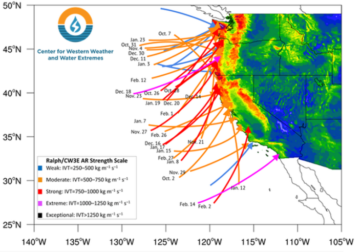
Atmospheric rivers are narrow, moisture‑laden plumes that travel from tropical oceans to California, delivering a large share of the state’s winter rain and snow, and a warming climate is making these rivers richer in water and potentially more hazardous.
Quick Answer
Atmospheric rivers (ARs) are long, narrow corridors of water‑vapor that form over warm tropical oceans and are steered toward the West Coast by the mid‑latitude jet stream. When the moist air encounters the coastal ranges and the Sierra Nevada, it rises, cools, and releases heavy precipitation. Scientific assessments (e.g., IPCC 2021) show that rising sea‑surface temperatures increase atmospheric moisture capacity by about 7 % per °C, strengthening ARs. Stronger ARs can refill reservoirs but also raise flood, landslide, and infrastructure risk, especially in steep terrain; the exact change in AR frequency remains uncertain.
Key Takeaways
- Atmospheric rivers transport up to 15 % of the planet’s water vapor, acting as “atmospheric highways.”
- In California they supply 30–50 % of annual precipitation, often as the dominant winter source.
- Observations from NOAA and the California Department of Water Resources show a statistically significant rise in Category 3 (strong) AR events since the 1980s.
- Warmer oceans increase each AR’s moisture load, allowing modern events to deliver up to 30 % more water than comparable events a century ago.
- Enhanced AR intensity amplifies flood, landslide, and infrastructure hazards while also offering larger water‑supply benefits.
What Is Atmospheric Rivers in California: What They Are and Why They’re Getting Stronger?
Atmospheric rivers are elongated plumes of water‑vapor, typically 400–600 km wide and several thousand kilometres long, that travel within the mid‑latitude westerly jet stream. Unlike ordinary rainstorms, which generate moisture locally, ARs are defined by the transport of moisture over great distances from tropical oceans to mid‑latitude landmasses. In California, ARs are the primary source of winter precipitation, delivering roughly one‑third to one‑half of total annual rainfall and snowfall, depending on the basin. The term emphasizes the river‑like flow of water vapor, and the phenomenon is sometimes called the “Pineapple Express” when the plume originates near Hawaii.
How Does It Work?
1. Moisture Generation Over Warm Oceans
Solar heating raises sea‑surface temperatures, especially in the tropical Pacific. Warmer water accelerates evaporation, and the Clausius‑Clapeyron relationship indicates that the atmosphere’s water‑vapor holding capacity grows by roughly 7 % for each degree Celsius of warming.
2. Organization by the Jet Stream
Upper‑level westerly winds align the moisture into a coherent ribbon‑like structure. The curvature of the jet stream steers the AR toward the West Coast, often following a predictable “pineapple‑express” track.
3. Orographic Lift Over Mountains
When the moist plume meets the coastal ranges and the Sierra Nevada, it is forced upward. Rising air cools adiabatically, causing water vapor to condense into clouds and precipitation. Lower elevations receive intense rain, while higher elevations experience heavy snow that rapidly builds the snowpack.
4. Runoff, Infiltration, and Water‑Resource Impacts
Precipitation can quickly become runoff, filling rivers and reservoirs. The proportion that infiltrates versus runs off determines groundwater recharge versus flood risk. The timing of AR arrival relative to reservoir capacity is critical for water‑management decisions.
What Does the Evidence Show?
Long‑term satellite records such as NASA’s Atmospheric Infrared Sounder (AIRS) and radiosonde networks reveal a steady increase in atmospheric moisture over the Pacific since the 1980s. A 2021 Intergovernmental Panel on Climate Change (IPCC) assessment reports that extreme precipitation events in mid‑latitude regions have become more intense, consistent with the observed rise in Category 3 ARs in California. Attribution studies using ensembles from NOAA’s Climate Model Intercomparison Project estimate that human‑induced warming accounts for roughly 40–60 % of the observed increase in AR strength over the past four decades. However, natural variability—including El Niño‑Southern Oscillation (ENSO) and the Pacific Decadal Oscillation (PDO)—continues to modulate AR frequency and tracks, making precise future projections challenging.
Main Causes or Drivers
Direct Climate Drivers
- Rising sea‑surface temperatures in the tropical Pacific increase evaporation rates.
- Enhanced atmospheric water‑vapor capacity follows the Clausius‑Clapeyron scaling of ~7 % per °C.
Underlying Human Influences
- Anthropogenic greenhouse‑gas emissions warm ocean surfaces and the lower atmosphere.
- Land‑use changes that alter regional albedo can modestly affect local circulation patterns.
Natural Modulators
- ENSO phases shift the jet stream, influencing AR tracks and intensity.
- The PDO alters multi‑decadal sea‑surface temperature patterns, affecting background moisture availability.
Environmental and Human Impacts
Environmental Impacts
Strong ARs deliver deep snow to the Sierra Nevada, sustaining downstream ecosystems during the dry season. Rapid snow accumulation can raise avalanche danger, and fast runoff can erode soils, destabilize slopes, and degrade riparian habitats. Wetland inundation may benefit some species but also facilitates invasive plant spread.
Human Health and Social Impacts
Flash floods and landslides threaten life safety, especially in low‑income neighborhoods built on floodplains. Post‑flood conditions can foster water‑borne pathogens, raising short‑term health risks. Displacement and property loss disproportionately affect vulnerable communities lacking resources for recovery.
Economic and Infrastructure Impacts
Intense ARs strain storm‑water systems, damage roads, and interrupt power supplies. While water‑resource agencies gain valuable inflow, the rapid timing often exceeds reservoir storage capacity, resulting in lost capture potential and costly emergency response.
Regional Differences
Coastal counties such as San Diego experience heavy rain within hours, whereas interior mountain regions receive deep snow that persists into summer. The Central Valley, shielded by the Coast Ranges, often sees amplified runoff from upstream mountains, increasing downstream flood risk. Northern California’s higher elevations and steeper terrain make landslides more common, while Southern California’s drier climate can produce flash floods in desert washes when an AR brings unexpected moisture.
What Scientists Know With High Confidence
- Atmospheric rivers transport a disproportionate share of the West Coast’s winter precipitation.
- Warmer ocean temperatures increase the moisture content of ARs, following well‑established thermodynamic principles.
- Orographic lift over the Sierra Nevada converts water vapor into heavy rain or snow, producing the bulk of California’s winter snowpack.
- Observational records show a statistically significant rise in the frequency of the strongest (Category 3) AR events since the 1980s.
What Remains Uncertain
The precise future change in AR frequency is uncertain because natural climate modes (e.g., ENSO, PDO) interact with anthropogenic warming in complex ways. Model simulations disagree on whether the number of AR events will increase, decrease, or remain stable, even as individual events become more moisture‑rich. Data gaps also exist in high‑resolution observations over the central Pacific, limiting precise attribution of individual ARs to climate change. Improved satellite retrievals and finer‑scale climate modeling are needed to narrow these uncertainties.
Common Misconceptions
Misconception: Atmospheric rivers are the same as hurricanes.
Reality: Hurricanes are tropical cyclones with a closed low‑pressure core and organized circulation, whereas atmospheric rivers are linear moisture plumes that can occur in any season and lack a cyclonic structure.
Misconception: All atmospheric rivers cause flooding.
Reality: Weak to moderate ARs often deliver beneficial rain or snow without exceeding drainage capacity; only the strongest events typically generate hazardous flooding.
Misconception: Climate change will eliminate drought by producing more rain.
Reality: While stronger ARs increase short‑term water input, they do not guarantee even distribution; drought can persist when precipitation is concentrated in a few intense storms followed by prolonged dry periods.
Solutions and Limitations
Response strategies focus on adapting water‑resource management and reducing flood exposure. Structural measures such as expanding reservoir capacity, upgrading levees, and reinforcing bridges can store excess runoff, but they require substantial capital investment and may impact river ecosystems. Nature‑based solutions—including wetland restoration, slope reforestation, and strategic river‑bank setbacks—enhance infiltration and reduce landslide risk, yet they depend on land‑use coordination and long‑term maintenance. Early‑warning systems that combine satellite monitoring with ensemble weather forecasts provide crucial lead time for evacuations, but prediction uncertainty remains for exact rainfall amounts and timing. No single approach fully resolves the trade‑off between water‑supply benefits and flood hazards; a portfolio of engineering, ecological, and policy actions is required.
What Individuals, Communities, and Governments Can Do
What Individuals Can Do
- Monitor local AR forecasts from the National Weather Service and heed evacuation orders.
- Prepare personal flood‑ready kits and develop family evacuation plans, especially if residing in flood‑prone areas.
- Support community watershed projects that increase green space and improve stormwater infiltration.
What Communities and Organizations Can Do
- Adopt zoning ordinances that limit new development on historic floodplains.
- Invest in green infrastructure—rain gardens, permeable pavements, and restored wetlands—to delay runoff.
- Participate in regional water‑budget planning that allocates AR water for groundwater recharge and ecosystem needs.
What Governments Can Do
- Fund high‑resolution climate modeling and AR monitoring networks, such as NOAA’s AR detection system.
- Provide grant programs for retrofitting critical infrastructure to withstand extreme precipitation.
- Integrate AR projections into long‑term water‑resource management, emergency‑response frameworks, and climate‑adaptation plans.
Synthesis
Atmospheric rivers are essential conveyors of moisture that sustain California’s water supply, yet a warming climate is making the strongest of these rivers more potent. Robust observations and climate‑model studies give high confidence that warmer oceans amplify AR moisture, while uncertainties remain about how often such events will occur in the future. Balancing water‑resource benefits against heightened flood and landslide hazards requires a mix of engineering upgrades, nature‑based solutions, and proactive governance, with individuals and communities playing supportive roles.
Frequently Asked Questions
What exactly is an atmospheric river?
An atmospheric river is a long, narrow corridor of water‑vapor that forms over warm tropical oceans and is steered toward the West Coast by the jet stream, releasing heavy rain or snow when it encounters mountains.
How do atmospheric rivers affect California’s water supply?
Atmospheric rivers deliver 30–50 % of California’s annual precipitation, providing essential rain and snow that refill reservoirs and build the Sierra Nevada snowpack, which sustains water supplies through the dry season.
Why are atmospheric rivers getting stronger?
Rising sea‑surface temperatures increase evaporation, and the atmosphere can hold about 7 % more moisture per °C of warming. This thermodynamic effect makes each river richer in water, allowing modern events to deliver up to 30 % more precipitation than historic storms.
What are the main hazards associated with stronger atmospheric rivers?
Stronger atmospheric rivers can cause rapid runoff, leading to flash floods, landslides, and damage to infrastructure, especially in steep or low‑lying areas where drainage capacity is limited.
What actions can communities take to reduce flood risk from atmospheric rivers?
Communities can adopt floodplain zoning, invest in green infrastructure such as rain gardens and restored wetlands, and improve early‑warning systems that combine satellite monitoring with ensemble weather forecasts.






Leave a Comment