
Planned construction of roughly 20,000 km of roads across tiger range countries by 2050 is projected to fragment core habitats, increase human access, and raise poaching risk, jeopardising long‑term tiger viability.
Quick Answer
Scientists estimate that about 20,000 km of new highways, feeder roads and access tracks will cut through tiger‑occupied landscapes by 2050. The primary mechanism is habitat fragmentation: roads break continuous forest into smaller patches, limiting tiger movement and exposing populations to humans. Evidence from the IUCN, WWF and national monitoring programmes links higher road density with increased poaching and human‑tiger conflict. While mitigation measures such as wildlife corridors could reduce impacts, the consensus is that unchecked road expansion poses a serious, long‑term threat to tiger conservation.
Key Takeaways
- Approximately 20,000 km of new roads are projected for tiger range countries by 2050.
- Roads fragment habitat, reduce prey availability, and increase human access.
- Fragmentation is associated with higher rates of poaching and human‑tiger conflict.
- Long‑term monitoring shows a negative relationship between road density and tiger occupancy.
- Wildlife corridors and overpasses can mitigate impacts but require strong governance and funding.
What Is 20000 km of New Roads Threaten Tiger Habitats by 2050 Study Finds?
The phrase refers to a synthesis of spatial‑planning studies, national infrastructure master plans and biodiversity assessments that together project roughly 20,000 kilometres of new highways, feeder roads and access tracks to be built within the geographic range of wild tigers by the middle of the 21st century. The assessment defines “tiger habitat” as forested or mixed‑use areas identified by the IUCN Red List and national wildlife agencies as core or buffer zones essential for breeding, hunting and dispersal. Existing roads are excluded; the focus is on projects that have entered formal planning or approval stages.
How Does It Work?
Road construction and habitat fragmentation
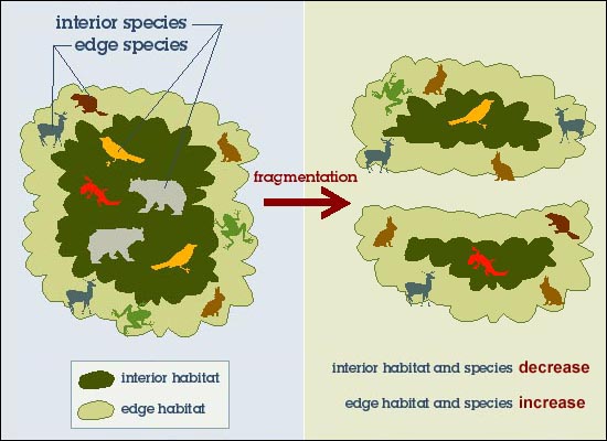
When a road is built, the surrounding forest is cleared for the right‑of‑way, creating an edge that alters microclimate, vegetation structure and prey distribution. The physical barrier limits the ability of individual tigers to move between patches, effectively reducing the functional size of each habitat fragment. Studies in the Terai‑Arc Landscape (India/Nepal) and the Sundarbans (Bangladesh/India) have documented reduced tiger movement across even low‑traffic roads.
Increased human access and poaching pressure
New roads provide easier entry for local communities, loggers and illegal hunters. The United Nations Office on Drugs and Crime (UNODC) reports that poaching incidents rise sharply within five kilometres of newly paved routes, because transport of carcasses and wildlife parts becomes faster and cheaper. Greater accessibility also raises the probability of livestock depredation, which can trigger retaliatory killings.
Feedback loops and ecosystem cascades
Fragmented habitats support fewer prey species such as sambar, chital and wild boar. Declining prey forces tigers to expand their home ranges, bringing them into closer contact with humans. This feedback loop can accelerate population declines and disrupt the predator‑prey balance that maintains forest health.
What Does the Evidence Show?
Long‑term monitoring by the Global Tiger Initiative (2022) indicates that tiger occupancy declines by an average of 0.5 % for every 1,000 km of road density increase within a protected area. A systematic review of peer‑reviewed studies (World Wildlife Fund, 2021) found that regions with road density above 3 km per 100 km² experienced a 12–18 % higher probability of tiger‑related human conflict. Remote‑sensing analyses by the European Space Agency (2020) confirm that road expansion in Southeast Asia has accelerated at a rate of 6 % per year since 2010, overlapping with key tiger corridors identified by the IUCN.
Main Causes or Drivers
Economic development goals
Governments in India, Indonesia and Myanmar prioritize road networks to stimulate trade, tourism and regional connectivity. Infrastructure projects are often justified by projected GDP gains, even when environmental impact assessments are limited.
Policy and planning gaps
Many national forest policies lack enforceable provisions for wildlife corridors. In several cases, road‑building agencies do not require biodiversity offset analyses, leading to “green‑light” approvals without mitigation.
Population pressure and land‑use change
Rising human populations in the foothills of the Himalayas and the Mekong basin increase demand for agricultural land, which is frequently accessed via new roads.
Environmental and Human Impacts
Environmental Impacts
Fragmentation reduces effective habitat area, creating smaller, isolated tiger subpopulations that are more vulnerable to inbreeding and stochastic events. The loss of an apex predator can cause mesopredator release, whereby smaller carnivores increase, potentially altering seed dispersal and forest regeneration patterns.
Human Health and Social Impacts
Increased human‑tiger encounters raise the risk of injuries and livestock loss, affecting food security for rural households. Conflict often results in retaliatory killings, undermining local trust in conservation authorities.
Economic and Infrastructure Impacts
While roads can improve market access, the costs of managing conflict and protecting fragmented habitats may offset short‑term economic benefits. Tourism revenue from tiger‑focused wildlife safaris can decline if populations become too sparse to guarantee sightings.
Regional Differences
In the Indian subcontinent, road projects are concentrated in the Western Ghats and the Eastern Himalayas, where tiger density is high and protected‑area connectivity is already limited. In Southeast Asia, the most extensive new road networks are planned in Sumatra and Borneo, regions where illegal logging already threatens forest integrity. Conversely, in Russia’s Sikhote‑Alin range, road expansion is modest and existing corridors remain relatively intact, highlighting that threat levels vary widely across the global tiger range.
What Scientists Know With High Confidence
- Habitat fragmentation caused by roads reduces tiger movement and genetic exchange.
- Increased human access correlates with higher poaching and conflict rates.
- Long‑term monitoring shows a negative relationship between road density and tiger occupancy.
- Well‑designed wildlife corridors can mitigate some fragmentation effects when properly enforced.
What Remains Uncertain
Key uncertainties include the exact magnitude of population loss under different road‑development scenarios, the effectiveness of specific crossing designs in varied topographies, and the long‑term socio‑economic outcomes for communities that depend on both roads and wildlife tourism. Improved fine‑scale monitoring and scenario modelling are needed to narrow these gaps.
Common Misconceptions
Misconception: Roads only bring economic benefits.
Reality: While roads can stimulate trade, the associated biodiversity loss and conflict costs can offset or even outweigh short‑term gains, especially where tourism and ecosystem services depend on intact tiger habitats.
Misconception: Tigers can adapt quickly to fragmented landscapes.
Reality: Tigers are large, territorial predators that require extensive, contiguous ranges; fragmentation disproportionately reduces their hunting efficiency and breeding success.
Misconception: Wildlife crossings solve the problem entirely.
Reality: Crossings improve connectivity but must be part of broader land‑use planning, enforcement and community engagement to be effective at scale.
Solutions and Limitations
Strategic planning that integrates wildlife corridors into road design is the most evidence‑based mitigation. Elevated overpasses and underpasses have reduced wildlife‑vehicle collisions by up to 80 % in studies from India and Malaysia. However, such structures are costly, require regular maintenance and may be bypassed if not aligned with natural movement routes. Policy reforms that mandate cumulative impact assessments can prevent the most damaging projects, yet implementation is uneven across jurisdictions. Community‑based monitoring can deter poaching, but it depends on sustained funding and trust building.
What Individuals, Communities, and Governments Can Do
What Individuals Can Do
- Support NGOs that fund wildlife‑corridor projects and anti‑poaching patrols.
- Choose tourism operators that follow certified wildlife‑friendly guidelines.
- Advocate for transparent environmental impact assessments in local elections.
What Communities and Organizations Can Do
- Participate in habitat‑monitoring programmes that use camera traps or citizen‑science apps.
- Develop community‑managed buffer zones that provide alternative livelihoods to reduce reliance on forest resources.
- Collaborate with engineers to identify optimal locations for wildlife crossings.
What Governments Can Do
- Incorporate mandatory wildlife‑corridor mapping into national road‑master plans.
- Allocate dedicated funds for the construction and maintenance of overpasses and underpasses.
- Enforce stricter penalties for illegal hunting in proximity to new roads.
- Promote cross‑border coordination, as tiger ranges often span multiple countries.
Closing Synthesis
The projected 20,000 km of new roads across tiger range countries represents a quantifiable pressure on one of the world’s most iconic apex predators. Strong scientific consensus links road‑induced fragmentation with higher poaching risk and reduced population viability. Although uncertainties remain around exact future population trajectories, the evidence base supports proactive mitigation—such as wildlife corridors, rigorous impact assessments and community engagement. Aligning development goals with conservation science offers a realistic pathway to preserve tiger habitats and the broader ecosystem functions they support for generations to come.
Frequently Asked Questions
How many kilometres of new roads are projected in tiger range countries by 2050?
Scientists estimate that roughly 20,000 kilometres of new highways, feeder roads and access tracks will be built within tiger‑occupied landscapes by the middle of the 21st century.
Why does road construction threaten tiger populations?
Roads fragment continuous forest, creating smaller habitat patches that limit tiger movement, reduce prey availability, and provide easier access for poachers and humans, which together increase conflict and mortality.
What evidence links road density to tiger decline?
Long‑term monitoring shows tiger occupancy drops by about 0.5 % for every 1,000 km of additional road density, and systematic reviews find a 12–18 % higher chance of human‑tiger conflict where road density exceeds 3 km per 100 km².
Can wildlife corridors and overpasses fully solve the problem?
Crossings can improve connectivity and cut wildlife‑vehicle collisions by up to 80 %, but they are costly, need maintenance, and must be integrated into broader land‑use planning and enforcement to be effective at scale.
What actions can governments take to protect tigers from road expansion?
Governments can mandate wildlife‑corridor mapping in road‑master plans, fund and maintain overpasses/underpasses, enforce stricter anti‑poaching penalties near roads, and coordinate cross‑border conservation strategies.





Leave a Comment