
Tides are short‑term, predictable water‑level changes driven by lunar and solar gravity, while sea level rise is a long‑term increase caused mainly by climate‑driven warming, melting ice, and thermal expansion.
Quick Answer
Tides are regular, daily fluctuations in ocean height caused by the gravitational pull of the moon and, to a lesser extent, the sun; they repeat on diurnal or semi‑diurnal cycles and are largely independent of climate change. Sea level rise, by contrast, is a gradual, multi‑decadal increase in the average height of the world’s oceans, driven primarily by thermal expansion of warming seawater and added water from melting glaciers and ice sheets. The two phenomena differ in cause, timescale, and implications: tides affect local navigation and coastal timing, whereas sea level rise reshapes coastlines, threatens infrastructure, and amplifies flood risk. While tides are well understood and predictable, the exact rate of future sea level rise carries moderate uncertainty due to complex ice‑sheet dynamics.
Key Takeaways
- Tides result from celestial gravity and follow predictable daily cycles.
- Sea level rise reflects long‑term climate warming, ice melt, and thermal expansion.
- Impacts of tides are immediate and localized; sea level rise influences regional and global coastlines over decades.
- High‑confidence science shows the planet’s average sea level has risen about 20 cm since 1900 (IPCC, 2021).
- Uncertainties remain about the contribution of Antarctic ice‑sheet dynamics to future rise.
What Is Tides vs. Sea Level Rise: What’s the Difference?
The term “tides” refers to the periodic rise and fall of sea surface height caused primarily by the gravitational attraction of the moon, with a secondary contribution from the sun. These forces generate bulges in the ocean that rotate with the Earth, producing high and low water levels typically twice each day at most locations. In contrast, “sea level rise” describes a sustained increase in the mean global ocean height, measured relative to a fixed land datum, and driven largely by anthropogenic warming. While both involve changes in water level, tides are short‑term and cyclic, whereas sea level rise is a long‑term trend that reshapes baseline conditions.
How Does It Work?
Mechanics of Tides
- Gravitational pull: The moon’s gravity exerts a stronger pull on the side of Earth facing it, creating a water bulge (high tide).
- Opposite bulge: Inertia causes a second bulge on the side opposite the moon, leading to a second high tide.
- Earth’s rotation: As the planet rotates, coastal locations move through these bulges, experiencing alternating high and low tides roughly every 12 hours (semi‑diurnal) or 24 hours (diurnal) depending on geography.
- Solar influence: When the sun, moon, and Earth align (new or full moon), solar gravity reinforces lunar pull, producing especially high “spring tides.” When they form a right angle (first and third quarters), tides are reduced, known as “neap tides.”
- Local modifiers: Coastal shape, ocean depth, wind stress, and atmospheric pressure can amplify or dampen tidal amplitudes.
Processes Behind Sea Level Rise
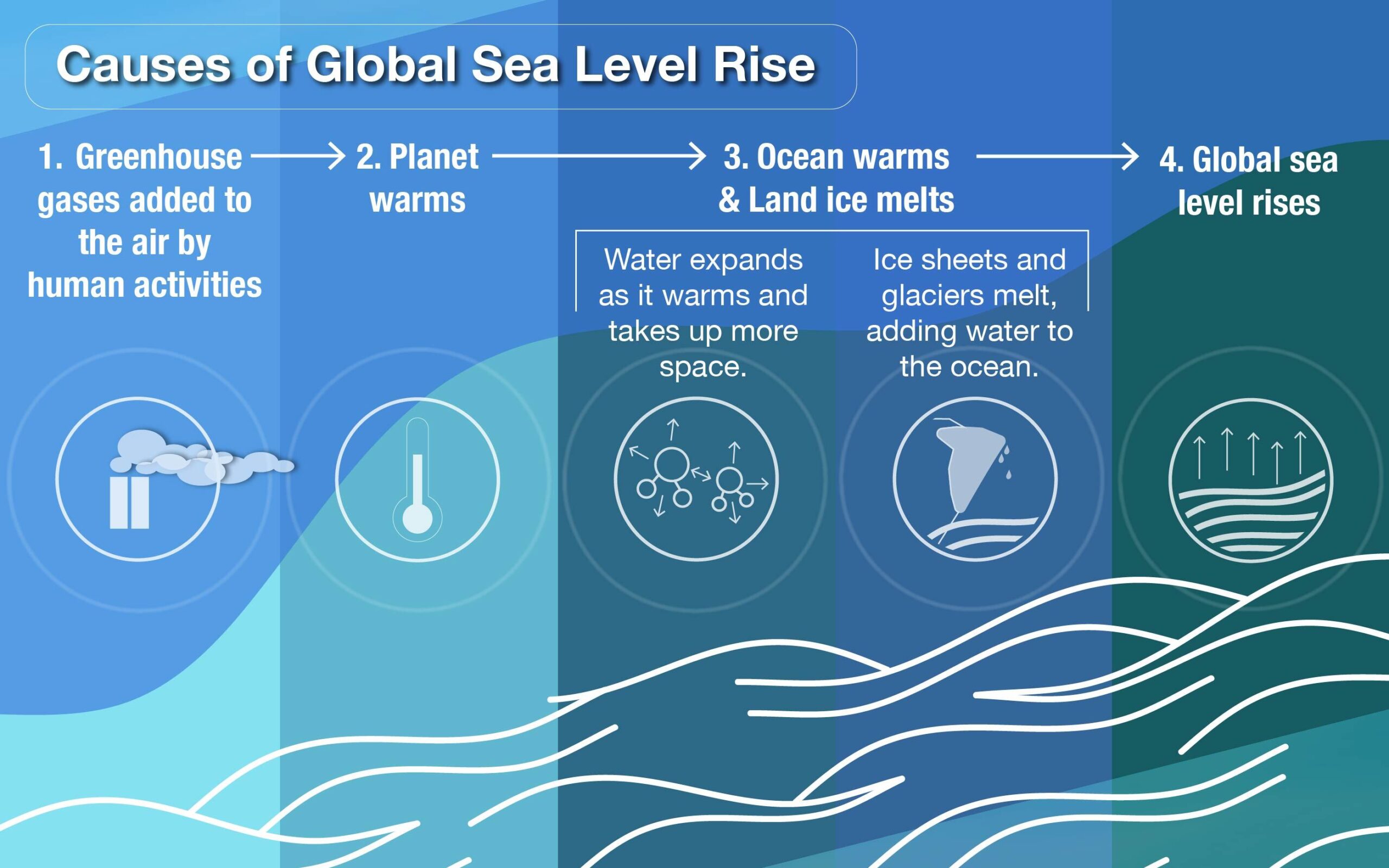
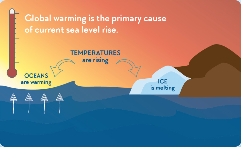
- Thermal expansion: Warmer water occupies more volume; ocean heat uptake has caused a measurable increase in sea‑surface height.
- Glacial melt: Mountain glaciers worldwide have been losing mass, contributing freshwater to the oceans.
- Ice‑sheet loss: The Greenland and Antarctic ice sheets discharge meltwater and iceberg calving, adding billions of tonnes of water annually.
- Land‑water redistribution: Groundwater extraction and reservoir storage can slightly modify regional sea level, though these are secondary effects.
- Feedbacks: Reduced sea‑ice extent in polar regions lessens albedo, modestly accelerating local warming and further melt.
What Does the Evidence Show?
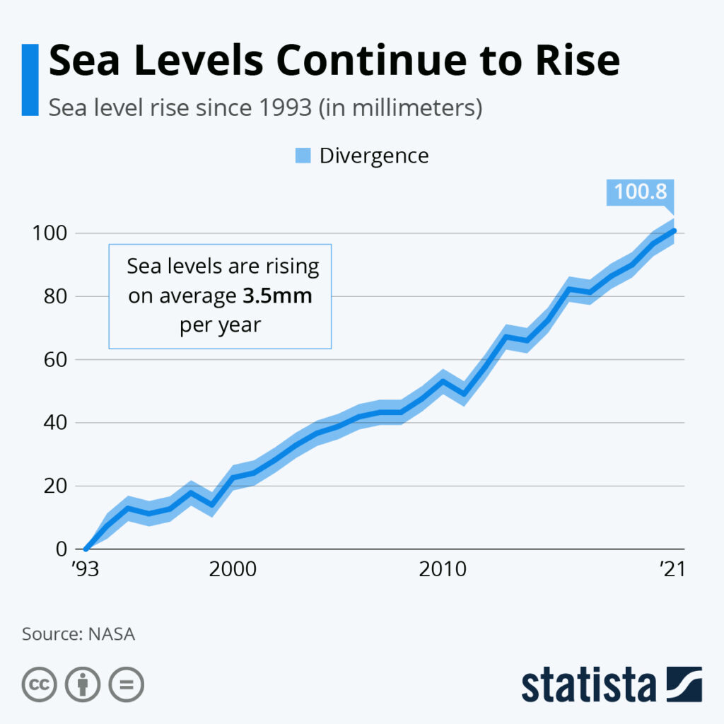
Long‑term tide‑gauge records, beginning in the 19th century, reveal a global mean sea‑level increase of about 20 cm (8 in) from 1900 to 2020, with an acceleration in the past two decades (IPCC, 2021). Satellite altimetry, operational since 1993, confirms a contemporary rise rate of roughly 3.3 mm yr⁻¹, consistent with the combined contributions of thermal expansion and ice melt reported by the National Oceanic and Atmospheric Administration (NOAA). Peer‑reviewed synthesis studies attribute approximately 40 % of the observed rise to warming‑induced expansion and 60 % to added meltwater (Church et al., 2013). Regional variations—up to 1 m higher rise along the western United States coast due to land subsidence—are documented in high‑resolution gravimetric and GPS observations.
Main Causes or Drivers
Direct Drivers of Tides
- Moon’s gravitational force (primary).
- Sun’s gravitational force (secondary).
- Earth’s rotation and ocean basin geometry.
Underlying Drivers of Sea Level Rise
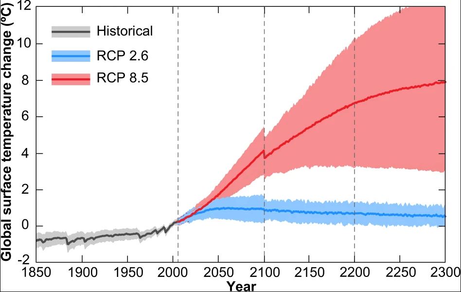
- Global temperature increase from greenhouse‑gas emissions (anthropogenic forcing).
- Melting of land‑based ice (Greenland, Antarctica, mountain glaciers).
- Thermal expansion of seawater as it absorbs excess heat.
- Regional land motion (subsidence or uplift) that modifies relative sea level.
Environmental and Human Impacts
Environmental Impacts
Rising seas inundate coastal wetlands, reducing their capacity to filter pollutants, store carbon, and buffer storm surges. Saltwater intrusion alters estuarine salinity regimes, threatening species adapted to brackish conditions. Habitat loss for nesting birds, mangroves, and coral reefs has been documented in low‑lying islands and deltaic systems.
Human Health and Social Impacts
Higher baseline water levels amplify the reach of storm‑surge flooding, increasing exposure to water‑borne pathogens and contaminant plume intrusion. Communities in delta regions (e.g., the Mekong, Nile) face heightened displacement risk, with implications for food security and cultural heritage.
Economic and Infrastructure Impacts
Coastal infrastructure—ports, roads, sewage systems—faces increased design flood levels. The U.S. National Oceanic and Atmospheric Administration estimates that a 1 m rise could cost $1 trillion in U.S. coastal property losses (NOAA, 2022). Insurance premiums and adaptation expenditures rise accordingly.
Regional Differences
In the Gulf of Mexico, land subsidence up to 10 mm yr⁻¹ compounds sea‑level rise, making New Orleans especially vulnerable. In the Pacific, small island states such as Kiribati experience relative sea‑level rise exceeding the global mean because of local uplift patterns and coral‑reef erosion. Conversely, parts of the Baltic Sea show slower rise due to isostatic rebound following the last glaciation.
What Scientists Know With High Confidence
- The moon’s gravity is the primary driver of tidal cycles.
- Global mean sea level has risen measurably since the early 20th century.
- Thermal expansion and meltwater from land ice together account for the majority of observed sea‑level rise.
- Future sea‑level rise will continue as long as global temperatures remain elevated.
What Remains Uncertain
Key uncertainties involve the rate at which the Antarctic ice sheet may contribute to sea‑level rise, especially the stability of the West Antarctic grounding lines. Model projections differ on whether a rapid, nonlinear discharge could add more than 0.5 m by 2100 under high‑emission scenarios. Regional variations in land motion and ocean dynamics also introduce uncertainty into local sea‑level forecasts.
Common Misconceptions
Misconception: Tides cause sea‑level rise.
Reality: Tides are short‑term oscillations that average to zero over time; sea‑level rise is a net increase in the mean water level, independent of tidal cycles.
Misconception: All coasts will rise at the same rate.
Reality: Local factors such as land subsidence, ocean currents, and gravitational effects of melting ice create significant regional differences.
Misconception: Sea‑level rise is only a future problem.
Reality: Observed rise of ~20 cm since 1900 already affects floodplain extents, especially during extreme weather events.
Solutions and Limitations
Adaptation strategies include restoring mangroves and wetlands to provide natural flood buffers, elevating or retreating infrastructure, and revising zoning codes to limit development in high‑risk zones. Mitigation—reducing greenhouse‑gas emissions—addresses the root cause of warming and thus long‑term sea‑level rise, but its impact unfolds over decades. Nature‑based solutions offer co‑benefits for biodiversity but may be limited by land availability and sea‑level thresholds beyond which restoration fails.
What Individuals, Communities, and Governments Can Do
What Individuals Can Do
- Support policies that aim for net‑zero emissions to curb future warming.
- Participate in local coastal‑restoration volunteer projects.
- Advocate for community flood‑risk assessments and resilient building practices.
What Communities and Organizations Can Do
- Develop and regularly update coastal hazard maps that incorporate both tidal ranges and projected sea‑level rise.
- Invest in green infrastructure—living shorelines, flood‑able parks, and elevated utilities.
- Implement managed retreat where protection is economically or ecologically unsustainable.
What Governments Can Do
- Enact and enforce stringent emissions reductions consistent with the Paris Agreement.
- Allocate funding for long‑term monitoring networks (tide gauges, satellite altimetry) to refine projections.
- Integrate sea‑level rise scenarios into national coastal‑development plans and disaster‑risk financing.
Synthesis of Key Points
Tides and sea level rise both influence coastal water levels, yet they differ fundamentally in cause, timescale, and consequence. Tides are regular, gravity‑driven cycles that have been predictable for millennia. Sea level rise is a climate‑driven, multi‑decadal increase that reshapes baseline sea levels, amplifies flood risk, and threatens ecosystems and human settlements. High‑confidence science confirms ongoing rise and its primary drivers, while uncertainties remain about the speed of Antarctic ice loss and regional outcomes. Effective responses combine mitigation of greenhouse gases with adaptive measures such as ecosystem restoration, resilient infrastructure, and informed planning. By distinguishing these phenomena, societies can better allocate resources, protect vulnerable coastlines, and prepare for a changing ocean future.
Frequently Asked Questions
What causes tides to occur?
Tides are caused primarily by the gravitational pull of the moon and, to a lesser extent, the sun, which creates bulges of water that move as the Earth rotates.
How is sea level rise measured?
Sea level rise is measured using long‑term tide‑gauge records and satellite altimetry, which together show a global average increase of about 20 cm since 1900.
Why do some regions experience faster sea level rise than others?
Local factors such as land subsidence, ocean currents, and the gravitational redistribution of meltwater cause regional variations, making some coastlines rise faster than the global average.
What are the main uncertainties about future sea level rise?
The biggest uncertainties involve how quickly the Antarctic ice sheet may lose mass and how regional land motion will interact with rising oceans, affecting local projections.
How can communities reduce risks from sea level rise?
Communities can restore wetlands and mangroves, elevate or relocate vulnerable infrastructure, and incorporate sea‑level projections into zoning and disaster‑risk planning.





Leave a Comment